Northern Virginia is an economic engine and with smart investments in walkable, inclusive, transit-oriented communities, the region can continue to thrive while reducing traffic and saving open space.
That’s why we support transit communities, revitalization of aging commercial corridors, and transit investments in Fairfax, Arlington, Alexandria, Loudoun, and Prince William.
Yet, some still push for a return to 1950s-style development and an outer beltway that will gobble-up farms and forests, and divert resources from existing transportation needs. That’s why we must also fight for reform in transportation policies at the state level and encourage smart growth policies statewide.
- Our work in the City of Alexandria >>>
- Our work in Arlington >>>
- Our work in Fairfax County >>>
- Our work in the City of Fairfax & Falls Church >>>
- Our work in Loudoun & Prince William counties >>>
Latest Happenings
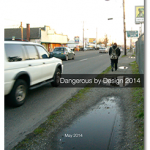
RELEASE: Dangerous by Design – with 843 pedestrian fatalities in 10 years, still work to do for safe streets in DC region
Washington, D.C. – A new report, Dangerous by Design, released today by the National Complete Streets Coalition, a program of Smart Growth America, provides information on pedestrian fatalities and injuries and ranks every state, metro region and county based upon the degree of danger faced by pedestrians. Comparatively, the Washington, DC region is safer for pedestrians than many other regions in the nation, ranking 35 out of the 51 largest metro areas (with 1 being the most dangerous). At the same time, the report found that 843 pedestrians were killed in the region from 2003 to 2012 — an unacceptable number no matter the DC region’s current ranking - and the dangers for pedestrians along suburban arterial roads is particularly high.
Why costs often creep on public-works projects
What do Metrorail’s Silver Line, the Columbia Pike streetcar in Arlington County and the Intercounty Connector in Maryland have in common? They have turned out to cost far more than initially projected. And, as often happens in such cases, the public is outraged over the bill.
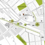
East Falls Church: Bridging I-66
Divided by I-66 and split between two jurisdictions, East Falls Church is on the cusp of big changes. View new developments and learn about plans for a vibrant, walkable and cycling-friendly neighborhood. Event materials: Program (PDF) East Falls Church area plan (online) Pedestrian and cyclist count
Coalition for Smarter Growth walking tour of East Falls Church
Come join us explore East Falls Church – an area centered on the Metro station and on the cusp of big changes. Divided by I-66 and split between two jurisdictions, the area is surrounded by well-loved neighborhoods, with parks and the booming W&OD bicycle trail.
Support for Sherwood Hall Lane bike lanes and traffic calming
We the undersigned organizations are writing in support of the proposal to include bike lanes and other traffic calming measures on Sherwood Hall Lane between Fort Hunt Road and Route 1 as part of the repaving project. The project is an excellent opportunity to improve safety for all users, including those who walk, bicycle and drive along Sherwood Hall Lane. Today the road offers overly wide travel lanes for extended stretches, inviting speeding and putting pedestrians, cyclists, joggers and other drivers at risk.