Montgomery County’s push for transportation investment paid a billion-dollar dividend Monday when the state committed money to eight county road, rail and bus priorities.
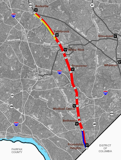
The lion’s share of funding — $680 million — will go to the Purple Line, a 16-mile light rail line planned to connect Bethesda and New Carrollton through Silver Spring. That includes $400 million for construction and $280 million already marked to buy land and finish the project’s design.
The state will seek a private company to run the light rail system.
Other projects, such as the Corridor Cities Transitway, Ride On Bus system and road improvements, will see smaller funding commitments from the state.
Standing above the Bethesda Metro station on Monday, Gov. Martin O’Malley announced the investments, saying they will bring needed jobs and traffic relief.
Led by County Executive Isiah Leggett (D), Montgomery pushed for an increase in the statewide gasoline tax in the 2013 legislative session. It sought a cash commitment from the state to the $2.2 billion Purple Line, as well as the Corridors Cities Transitway, a 15-mile bus rapid transit line connecting Clarksburg to the Shady Grove Metro station, estimated to cost $545 million.
Over the “last few decades,” Maryland stopped making necessary investments to build and maintain its transportation infrastructure, O’Malley (D) said Monday.
“The failure to act, the failure to make those better decisions, had a huge cost,” he said.
Time, jobs and the environment were sacrificed, he said.
Not everyone who heard the news on Monday was on board.
Opponents included about two dozen members of Friends of the Capital Crescent Trail, some of whom waved signs while others shouted slogans.
The western portion of the light rail is set to run along the Georgetown Branch section of the Capital Crescent Trail, from downtown Bethesda through the Columbia Country Club and across Connecticut Avenue.
“You couldn’t buy 20 acres inside the Beltway today to build a park. Why would you tear one down?” Ajay Bhatt, president of the group, asked in an email.
Running the Purple Line next to the trail, Bhatt said, would be “turning a serene tree-canopied nature trail through quiet neighborhoods enjoyed by thousands of young and old bikers, walkers and runners weekly into a shade-less ribbon of asphalt alongside twin sets of railroad tracks beneath high-power electrical lines with 250 daily trains passing at 45 mph.”
Deborah Vollmer of Chevy Chase said the rail line will lead to incalculable loss along the hiker-biker trail that, at points, parallels the Purple Line’s planned path. She said she is not opposed to mass transit, but the rail should be buried to avoid damaging the park-like atmosphere of the trail.
Another vocal opponent is Chevy Chase Councilman John Bickerman, who took issue with the announcement that the state would seek a private company to run the system.
“It’s an abomination, farming out this basic government service to the private sector,” Bickerman said. “It shouldn’t be contracted out. What if the revenues come in lower? What if the contractor doesn’t get the return that he’s expecting and the contractor goes belly up? Then what happens?”
Maryland lawmakers this spring passed the Transportation Infrastructure Investment Act — which raised taxes on gasoline and diesel — to bring $4.4 billion in new investment and 57,000 jobs in the next six years, officials said.
Flanked by dozens of state lawmakers, local leaders and members of the building trade, O’Malley said Montgomery’s share of that money will include the following:
• $400 million for construction of the Purple Line, which comes on top of $280 million announced previously to buy land and finish the project’s design.
• $125 million to construct a new interchange along Interstate 270 at Watkins Mill Road.
• $100 million to buy land and design the Corridor Cities Transitway.
• $85 million for Montgomery’s Ride On Bus system.
• $25 million to build and relocate a section of Md. 97 (Georgia Avenue) to bypass the center of Brookeville.
• $7 million to build interchanges at U.S. 29 and Musgrove Road and at U.S. 29 and Fairland Road.
• $3 million to design the widening of Md. 124 (Woodfield Road) from Midcounty Highway to south of Airpark Road.
• $3 million for planning to evaluate possible improvements in the Md. 28/Md. 198 corridor between Md. 97 and Interstate 95.
Lt. Gov. Anthony Brown shepherded a bill through the General Assembly this year that became the state’s new public-private partnership law. He said the state will deliver the Purple Line as its first and largest transit partnership with private industry. The state will seek a private company to build and operate the line.
“It’s a project that is going to connect our communities and grow our economy,” said Brown (D), who is running for governor in 2014, when O’Malley can’t run again because of term limits. “With the additional $400 million the governor just announced, we are showing how serious we are to delivering the Purple Line now.”
Montgomery looks to add 100,000 jobs through its efforts in the Great Seneca Science Corridor, Shady Grove, White Flint and White Oak, Leggett said.
“However, all of that depends on improvement in our transportation infrastructure,” Leggett (D) said. “Without that [investment], those jobs may come to a screeching halt.”
County leaders warned in December that without dedicated funding and clear state commitment to the project, the Purple Line, which is almost completely designed, would stall in its tracks.
“All of this is about better choices,” O’Malley said.
For transit advocates, the state commitment for the Purple Line was tempered by concerns over continued investment in highway projects.
Cheryl Cort, policy director of the Coalition for Smarter Growth, said investing in highway expansion projects only gives drivers temporary traffic relief and encourages more driving, not the transportation choices residents deserve.
Staff Writers Agnes Blum and Sylvia Carignan contributed to this report.
Click here to read the original story>>