Category: News

Bi-County Parkway debate fueled by research from both sides

One of our regular readers brought to our attention an issue that we haven’t been covering: Northern Virginia’s proposed Bi-County Parkway. The parkway would connect Prince William and Loudoun counties, but it has sparked an impassioned debate about our region’s growth trends.

outter beltwayOn the one side, the Coalition for Smarter Growth has done research that says that the parkway would create more sprawl, congestion, and traffic. CSG released the findings of a study on the subject last week and proposed a “common-sense, comprehensive alternative.” (CSG, 7/17)

On the other side, the 2030 Group – led by developer Bob Buchanan – commissioned a report from GMU’s Stephen Fuller which determined that our region’s continued growth will include a big increase in car use. The group is using this finding to support their push for the parkway. (WaPo, 7/21)

Here’s more context for the debate – the Washington Post’s coverage since September 2012. We’d love to hear your thoughts on the subject in the comment section. What are the pros and cons? (The good and the bad, not the professionals and convicts.)

Click here to read the original story>>

Leesburg Council Passes Resolution Against Bi-County Parkway

The Leesburg Town Council voted 5-2 Tuesday night to pass a resolution opposing the North-South Corridor and its components, despite firm requests – some have called them threats – from Loudoun Board of Supervisors Chairman Scott K. York and Loudoun Chamber President Tony Howard not to do so.

The resolution opposes construction of the Bi-County Parkway (formerly the Tri-County Parkway until shifted west several years back), which is a component related to the North-South Corridor aimed at improving connectivity between Prince William County and Dulles International Airport and the surrounding area. The corridor itself actually refers to an area, not a specific road; however, the construction of the Bi-County Parkway would complete a new direct four-lane path from I-95 in Prince William County to Route 50 in Loudoun. In its entirely, it would link I-95 all the way to Route 7. All segments of that connection are planned for at least four lanes of traffic, with few interchanges and plenty of traffic lights.outer beltway 2

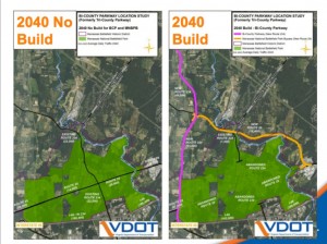
The Loudoun Chamber and Board of Supervisors as well as the state have put their support behind project, but a majority of the Leesburg Town Council believes the road would spark denser development in Loudoun’s Transition Policy Area and dump traffic on Route 7 that would overflow onto town streets.

“The problem I have with the North-South corridor is that … as with Prince William County, they’re concerned about protecting the Rural Crescent; in Loudoun we’re concerned about protecting the low-density transition area,” said Mayor Kristen Umstattd.

Umstattd and at least one other councilmember also pointed out that Interstates 95 and 81 were only four lanes in sections.

“I don’t want to see another I-95 or Interstate 81 coming up from 95 and dumping onto Route 7,” Umstattd said.

The Chamber’s Howard called that point “a completely misunderstood representation of what this project is proposed to be.”

Howard said the four-lane road, which would have traffic signal primarily instead of interchanges, would in no way resemble those interstates.

“I’m very disappointed in the vote,” Howard said. “The actions they took yesterday weren’t necessary. It’s not reasonable that Leesburg will see any increase in traffic, because the Bi-County Parkway is 15 miles away.”

Councilmember Marty Martinez said the council could not look only at the Bi-County portion of the corridor because the roads will all connect, and drivers will find them.

“They’re all going to connect eventually,” he said. “It is going to impact Leesburg and I have to be concerned about that.”

Councilwoman Kelly Burk said the chamber was putting business interests over those of residents.

“Economic development gets higher consideration than anything else – the environment, the community,” she said.

The council’s resolution included a list of projects it would prefer to see funded instead of the Bi-County Parkway, which the council requests undergo further environmental study.

Council members Kevin Wright and Tom Dunn voted against the resolution.

Opponents of the road held a conference call last week to offer an alternative plan that they said would keep 45,000 vehicles off of Loudoun’s roads. While those vehicles trips, the group acknowledged, would still exist somewhere in the region, they would have fewer impacts on the Manassas National Battlefield Park.

“The Bi-County Parkway makes conditions worse and doesn’t address some important needs,” said Stewart Schwartz, of the Coalition for Smarter Growth, one member of the group of opponents.

Opponents of the road have also argued that it primarily serves business needs, but forecasts show commuters would be the primary users, using the road to escape other congested routes. That would lengthen routes for commuters and prove a minimal benefit and other users crowd the new route, according to opponents.

Fin the full report with executive summary and appendices here.

The group offering the alternative vision for the parkway includes the Southern Environmental Law Center, the Coalition for Smarter Growth, the Piedmont Environmental Council, the National Trust for Historic Preservation, the National Parks Conservation Association.

Virginia Sec. of Transportation Sean Connaughton, who is the former chairman of the Prince William County Board of Supervisors, previously presented his case for the road in an editorial letter; read the letter here.

Howard said the disagreement would not harm the relationship between the town and chamber.

“We’re still friends,” he said. “The chamber’s going to continue to advocate for the town’s projects.”

The council’s resolution included a list of favored projects, including interchanges at the Route 15 Bypass and Edwards Road, Battlefield Parkway and Route 7 and Battlefield and the Leesburg Bypass. In addition, the resolution urges support for construction of Crosstrail Boulevard between Route 7 and Sycolin Road.

Photo courtesy of VDOT.

Click here to read the original story>>

Bi-County Parkway in Virginia will add congestion, groups argue

A coalition of groups critical of the proposed Bi-County Parkway has released a report it says bolsters its case that the roadway could worsen traffic congestion in Loudoun and Prince William counties.

Norman L. Marshall, president of Smart Mobility, which conducted the analysis using data from the Virginia Department of Transportation, said the north-south roadway would create new bottlenecks.

“Building the [Bi-County Parkway] would generate more overall traffic — and more north-south travel — in the study area than would be the case if the [Bi-County Parkway] is not built,” the report said.

The study, released last week, is the latest in the back-and-forth battle over the proposed parkway, which would provide a north-south connection between Loudoun and Prince William counties. Supporters of the roadway say it is needed to accommodate future population growth and promote economic development.

“We’re not just talking about the present, we’re talking about the future,” said Bob Chase, head of the Northern Virginia Transportation Alliance, which backs the road. “The best way to ensure that more people in this region have shorter commutes is to provide more jobs closer to where people live and have a grid that gives them a chance to move north, south, east and west.”

But opponents argue that state officials need to focus on improving existing roadways — particularly east-west connections, such as Interstate 66 — before investing in new roads.

“We believe that their case just doesn’t hold up, from speculative cargo claims, to congestion, to impact on the historic resource and Rural Crescent, to their failure to invest in the many critical projects residents and commuters need today,’’ said Stewart Schwartz, executive director of the Coalition for Smarter Growth, one of the groups that commissioned the $12,000 study.

In a conference call with reporters, leaders of those groups said Marshall’s analysis found that a package of alternative roadway improvements they have proposed would do more to relieve congestion and preserve the historic Manassas Civil War battlefield than the Bi-County Parkway.

The coalition’s plan “addresses a broader set of goals and better protects a historic resource,” Schwartz said.

The Piedmont Environmental Council, the Southern Environmental Law Center, the National Trust for Historic Preservation and the National Parks Conservation Association also sponsored the study.

Earlier this year, VDOT conducted its own analysis of the proposed parkway and the list of projects proposed by the coalition. That study showed that if the parkway is built, traffic at many key points along the north-south route would improve.

VDOT’s “thorough” analysis indicates that the Bi-County Parkway is needed, said Tom Fahrney, the department’s project director for the parkway. The study recognizes that traditional commuting patterns have changed in Northern Virginia, he said.

“The jobs are starting to be located outside of the Beltway, and there’s a need for facilities like the Bi-County Parkway to get folks from Prince William to Loudoun,” Fahrney said. “If this road is not implemented, rural roads that are not safe will carry much more traffic than they are today, and we’ll have congestion and safety problems.”

Virginia transportation officials said the coalition’s study assumed that less development would take place in the area — a major difference between the two reports.

VDOT’s study also looked at the project alternatives proposed by the advocacy groups. Transportation officials said those proposals, which include improvements to the Route 28 and I-66 interchange, building interchanges on the Route 234 Bypass south of I-66 and extending Metrorail service from Vienna to Centreville, would cost more than $6 billion and take decades to complete. Coalition groups argue that VDOT’s analysis is misleading because their approach is far more comprehensive.

The coalition’s report comes at a time when some senior elected officials, including Del. Tim Hugo (R-Centreville) and Rep. Frank Wolf (D-Va.), say additional study is needed before the project moves forward.

In June, the Commonwealth Transportation Board, a state body, voted to advance plans tobuild the parkway. But an additional agreement in principle to build the road must be signed by VDOT, the Federal Highway Administration, the state Historic Resources Department and the National Park Service before the project can more forward. State transportation officials hope that will be completed by this fall.

Click here to read the original story>>

RELEASE: Bi-County Parkway Would Increase Congestion and Damage Manassas Battlefield

VIRGINIA — Today, a coalition of conservation, preservation, and smart growth organizations strongly questioned the overall benefit of the Virginia Department of Transportation’s (VDOT’s) proposed “Bi-County Parkway” in Loudoun and Prince William counties. The groups released an analysis of the controversial new highway’s impact on the amount of travel and congestion — comparing it to a proposed package of projects that would improve transportation in the area. The analysis shows that the alternative projects would be more beneficial to the region than the Bi-County Parkway would be.

ADVISORY: Rethinking the Bi-County Parkway

A coalition of five historic preservation, conservation, and smart growth organizations will be releasing a report on Tuesday, July 16 assessing the performance of the proposed Bi-County Parkway compared to a set of alternative investments. The authors and their traffic modeling consultant will brief interested members of the media during a 10:00 am conference call.

New bus rapid transit plan won’t require more property along Md. 355

West Chevy Chase residents no longer have to worry about a “Green Mile” marred by bus lanes down its middle, which would have meant widening the road, and possibly acquiring land through eminent domain.

That idea has been removed from the latest draft of the Countywide Transit Corridors Functional Master Plan, which the Montgomery County Planning Board approved on Thursday.

In April, when the planning board OK’d dedicated bus lanes on Md. 355, stretching from Friendship Heights up to the Rockville Metro, some residents of West Chevy Chase protested loudly.

The planning board listened and the new plan represents that, said Larry Cole, the Montgomery County Planning Department’s lead planner.

The proposed rapid transit bus lanes are part of the comprehensive Countywide Transit Corridors Functional Master Plan that is meant to improve transportation options, be more environmentally friendly, and support local businesses, according to county planners.

The plan to use median bus lanes has been moved from Phase Two into the appendix. The County Council, if and when it adopts the plan, will not be adopting the appendix, Cole said. It is there for background and guidance for future decisions.

There will still be dedicated bus lanes on Md. 355, but they will run along curbed lanes. The county can create a curb lane without having to acquire anyone’s property.

Another change is the lanes on Md. 355 will now run as dedicated bus lanes from the Friendship Heights Metro up to Shakespeare Boulevard in Germantown, and then as mixed-traffic lanes up to Redgrave Place in Clarksburg. Most of what had been in Phase Two has been moved into the appendix, Cole said. Exceptions were made for corridors and jurisdictions with their own planning authorities.

Alex Posorske, the managing director of the Coalition for Smarter Growth, called the plan “groundbreaking.”

“No other suburban region in the D.C. area is putting out something like this,” Posorske said.

The county is expected to add more than 200,000 residents in the coming decade and traffic will only get worse, Posorske said.

He called rapid transit bus lanes one leg in a three-legged stool. The other two legs, he said, were the Purple Line and the Washington Metropolitan Area Transit Authority.

“The trend is clear, people are driving less and less,” Posorske said. “There’s a real sea change in how people look at this.”

An interim copy of the plan should be available online by the end of the week, and the County Council is scheduled to take it up sometime in September.

Click here to read the original story>>

BRT Supporters Have Different Views As Plan Heads To Council

mocorts

Bus Rapid Transit supporters are split on the Master Plan the county’s Planning Department will likely send to the County Council next week on the new transportation system.

Some are still worried language inserted into the plan that would require “a thorough traffic analysis” before any BRT system is implemented severely waters down the plan and contradicts the basic point of making roads move more people instead of more cars.

Meanwhile, the Coalition For Smarter Growth, which is lobbying for a BRT network that would include a controversial transitway on Rockville Pike/MD 355, praised the Planning Board for taking “a major step forward.”

“This plan is one of the most extensive and progressive transportation plans of any suburban community in our region, and is in keeping with Montgomery County’s record of innovation in land use transportation and housing policy,” CSG Executive Director Stewart Schwartz said in a statement.

The Action Committee for Transit wrote a letter to the Planning Board before a worksession on the plan last Thursday urging it to reconsider the “thorough traffic analysis” language.

ACT is concerned a traffic study from county transportation planners at time of facility planning would make it more difficult to dedicate existing lanes to the buses in the BRT network, thus reducing the amount of all-traffic lanes.

At the Thursday worksession, the Planning Board amended the language by saying the thorough traffic analysis “should be performed” instead of “must be performed,” and only “where lane repurposing is recommended.”

Planning Board Chair Francoise Carrier advocated a plan that would ease concerns from drivers worried about how fewer lanes would affect their commutes. On Thursday, Carrier said the Board should consider how the repurposing lanes debate would play out before the County Council, which is expected to take up Bus Rapid Transit in September.

“There is a tension between sending up a plan that’s easier to adopt or sending up the plan thats bolder,” Carrier said.

Planning Commissioner Casey Anderson made it clear throughout the process he’s in favor of a bolder option that would include repurposed lanes where needed. Planning staff has said a lane each way on MD 355 would need to be repurposed through downtown Bethesda and Chevy Chase because there is no room to build an additional lane.

There has already been much opposition to the idea of repurposing lanes from neighborhood groups in Silver Spring and Chevy Chase and residents in Bethesda.

“It’s almost like you’re a dog that’s been beat too much and you’re afraid you’re going to get hit again when you start talking about, ‘Oh, don’t worry. We’re not going to do [lane repurposing] everywhere,’ before you even get started,” Anderson said.

Kelly Blynn, an organizer for the Coalition for Smarter Growth, said while the plan is a break from thinking that often shortchanged transit in favor of single-occupancy vehicles, the group is still concerned about new language from the State Highway Administration.

“However, Blynn expressed concern that other new language in the plan, pressed by the State Highway Administration, would place too high of a standard on moving cars through without considering a more proper standard of what approach would move the most people,” read the group’s press release.

Photo courtesy of Montgomery County Planning Department.

Click here to read the original story>>

D.C. planners drop proposal to end minimum parking rule for developers

Bowing to vocal opposition, District planners have backed off a controversial proposal to eliminate long-standing requirements that developers in some areas include parking spaces in their projects.

The decision not to wholly abandon “parking minimums” in outlying neighborhoods served by Metrorail and high-frequency bus lines comes as planners prepare to submit a wholesale rewrite of the city’s zoning code for approval by the Zoning Commission and shortly after opponents repeated their concerns at a council hearing.

The elimination of parking requirements in “transit zones” had been promoted zealously by Harriet Tregoning, director of the Office of Planning, and her deputies as a necessary response to a city growing more populous and less car-dependent. But residents in some neighborhoods viewed the proposal skeptically, claiming it was based on unfounded assumptions and would only worsen the scarcity of curbside parking.

Tregoning disclosed the change during an interview Friday on WAMU-FM, where she acknowledged she had got “a lot of feedback” about the parking changes. “It’s certainly in response to what we’ve heard from a lot of people,” she said.

In a subsequent interview, Tregoning said the planning office still intended to pursue elimination of parking minimums downtown and in fast-growing, close-in neighborhoods such as the Southwest Waterfront and NoMa. But in other areas eyed for the change, she said, the minimums would be “substantially” reduced rather than eliminated entirely.

“A lot of people were very, very concerned with the concept of no parking minimums,” she said. “I wanted to take that out of the discussion so we could focus on what is reasonable.”

Opponents “seemed to be really hung up by what they perceived as an ideological position,” she added. “I’m not an ideologue. I’m very practical. The practical effect is not very different.”

For a multi-unit residential building under the new proposal, Tregoning said, developers would have to create one parking space for every three units in most areas. They could also apply to the Board of Zoning Adjustment for a “special exception” to the minimum. Under current rules, the minimums vary but often require one space for every two units.

The zoning rewrite is nearing the end of a five-year process that has included discussions about liberalizing rules for “accessory” apartments and corner stores in residential neighborhoods. But the parking debate emerged over the past several months as by far the most contentious point of discussion, generating push-back from several neighborhood groups and AAA Mid-Atlantic.

The decision to back off the elimination of parking minimums vexed a group of activists who view it as a cornerstone of efforts to make the city denser and more transit-oriented.

Stewart Schwartz, executive director of the Coalition for Smarter Growth, which had rallied support for the measure, said Sunday it was “disappointing” to see Tregoning ease off a measure that could have helped make housing more affordable by lowering development costs.

“I think it would have been much simpler and effective” to eliminate the minimums and allow the market to dictate how much parking developers provide, he said, adding that “we’ll still call for the cleaner, market-based approach” at the Zoning Commission.

Some leading skeptics of the original proposal said it was too soon to tell if the revised parking-minimum measures would prove acceptable.

“It’s fine, but I’m not sure it goes far enough,” said Alma Gates, who has monitored the zoning rewrite for the Committee of 100 on the Federal City, a group of civic activists with a special interest in planning matters. “I’m waiting to see it in writing. . . . We’re talking about a big issue here. It affects everyone who has a car or [is] thinking about a car or coming to Washington.”

Juliet Six, a Tenleytown resident who has been vocal in opposing the parking measures, voiced extremely cautious optimism about Tregoning’s comments. She suggested that the announcement was calibrated to create an illusion of consensus as the debate moves to the Zoning Commission. “This is one way to take the heat off,” she said.

Tregoning acknowledged the change would “make it easier” for the zoning revision to gain the commission’s approval. The planning office is expected to submit the rewritten zoning code, totaling more than 700 pages, to the commission July 29. It is unclear when the body will hold hearings and give its final approval.

Click here to read the original story>>

Statement on DC Office of Planning Decision on Parking Minimums

FOR IMMEDIATE RELEASE
JULY 12, 2013

CONTACT: Alex Posorske, (202) 675-0016 ext. 126

Statement on DC Office of Planning Decision on Parking Minimums

WASHINGTON, D.C. — Today on the Kojo Nnamdi show on WAMU, the Director of the DC Office of Planning, Harriet Tregoning, announced that DCOP was scrapping its proposal to eliminate parking minimums in transit zones.  The decision was also reported in the City Paper.

“We are disappointed that the opposition to progressive reforms has caused the city to back down on the important reform of removing minimum parking requirements.  Parking minimums have driven up the cost of housing in a city that needs more affordable housing. The costs of too much parking are being passed on to all residents even if they want to save money by living car free,” said Stewart Schwartz, Executive Director of the Coalition for Smarter Growth.  “Parking mandates are a legacy of a different era and have hurt America’s cities as Matt Yglesias so clearly laid out Slate this week.”

Greater Greater Washington has covered the issue extensively including a response today.

“We are waiting to review the new proposal from DCOP and we hope that it will still move our city in a more affordable and sustainable direction.  We understand that there will be no minimums throughout our expanded downtown from the West End to NOMA and to our two revitalizing riverfronts,” said Schwartz.  “Moreover, parking requirements will still be lowered in the city’s transit zones. That’s as it should be.  With the expanded transit, walking, biking, and carsharing options that DC now offers, we shouldn’t be mandating more parking than we need or than people will use.”

The Coalition for Smarter Growth will be continuing its campaign for a progressive update to the city’s outdated zoning code including rollback of parking minimums, easier requirements for accessory dwelling units, corner stores in rowhouse neighborhoods, and other components that will make the code easier to understand and more appropriate for a modern, transit-oriented city.


About the Coalition for Smarter Growth

The Coalition for Smarter Growth is the leading organization in the Washington D.C. region dedicated to making the case for smart growth. Our mission is to promote walkable, inclusive, and transit-oriented communities, and the land use and transportation policies needed to make those communities flourish. To learn more, visit the Coalition’s website at www.smartergrowth.net.


###

Montgomery Rapid Transit System Takes Major Step Forward with Planning Board Approval

FOR IMMEDIATE RELEASE
JULY 12, 2013

CONTACT: Alex Posorske, (202) 675-0016 ext. 126

Montgomery Rapid Transit System Takes Major Step Forward with Planning Board Approval

A new county-wide rapid transit system in Montgomery County took a major step forward yesterday when the Montgomery County Planning Board unanimously approved a master plan for the system.

Transit advocates hailed the Planning Board’s decision, noting that with Montgomery projected to add more than 200,000 people in the coming decades, it is critical to invest in new transit infrastructure now.

“This plan is one of the most extensive and progressive transportation plans of any suburban community in our region, and is in keeping with Montgomery County’s record of innovation in land use transportation and housing policy,” said Stewart Schwartz, Executive Director of the Coalition for Smarter Growth.

“Rapid Transit represents Montgomery’s best, most affordable option for providing needed traffic relief to residents,” Schwartz said. “The old model of building ever more and wider roads for cars has not worked; we have to figure out how to move more people, more sustainably, with the infrastructure we have and Rapid Transit will do that.”

The plan lays the groundwork for a high quality transit network, based on successful bus rapid transit systems around the country, which would connect the County’s key economic and commercial centers, many of which are not currently served by Metro. The service would operate like Metrorail on county roadways, including features like dedicated lanes, comfortable stations, off-board fare payment, and frequent, speedier service to provide commuters relief from some of the longest commute times in the nation.

After reviewing hundreds of public comments, the Board spent many hours making edits and additions to this long range plan. One key change was the inclusion of a “performance standard” that would help ensure the County commits to a high level of transit service.

Kelly Blynn, Montgomery County Transit Organizer for the Coalition for Smarter Growth, highlighted that piece, noting that it was a break from the thinking of the past that often unfairly shortchanged transit.

“In order for this plan to be successful, we must be willing to place transit on equal footing with cars, and dedicate car lanes to transit where it can move more people than individual vehicles can,” Blynn said.

However, Blynn expressed concern that other new language in the plan, pressed by the State Highway Administration, would place too high of a standard on moving cars through without considering a more proper standard of what approach would move the most people. “It’s something we will be monitoring,” said Blynn.

In addition, the Board increased the size of the network, adding a critical connection on the map to Clarksburg, a planned community in need of transit options. Upcounty activists cheered the move.

“The Upcounty is the fastest growing region of Montgomery County,” said Upcounty Citizens Advisory Board member Beth Daly. “The extension of Rapid Transit north on 355 is a step in the right direction to for Clarksburg residents, offering them an express transit option to get to Shady Grove Metro and work centers quickly.”

The Board will now send its recommendations, officially known as the Countywide Transit Corridors Functional Master Plan to the County Council, who will review the plan starting in September. The plan will most likely first be reviewed by the Transportation, Infrastructure, Energy and Environment Committee, and then move to the full Council.


About the Coalition for Smarter Growth

The Coalition for Smarter Growth is the leading organization in the Washington D.C. region dedicated to making the case for smart growth. Its mission is to promote walkable, inclusive, and transit-oriented communities, and the land use and transportation policies needed to make those communities flourish. To learn more, visit the Coalition’s website at www.smartergrowth.net.

###