On Saturday, June 1, 2013, the Coalition for Smarter Growth partnered with Wheaton Urban District Advisory Committee to tour recent and upcoming changes in “A Walkable Wheaton.” Montgomery County Executive Ike Leggett and County Council President Nancy Navarro toured new developments and were joined by speakers from Kittelson & Associates, Housing Opportunities Commission, Latino Economic Development Center, and Just Up the Pike.
Author: Andrew Brown
Preservation Virginia lists land slotted for Tri-County Parkway as ‘endangered’
Historic Civil War parkland slotted for a controversial new parkway that would connect the counties of Prince William and Loudoun has made the “endangered” list of one of the oldest non-profit preservation organizations in the country.
Preservation Virginia, founded in 1889, focuses on the preservation of historic sites around the state, including Jamestown and the Cape Henry Lighthouse in Virginia Beach. For the first time, the group included land slated for the proposed Tri-County Parkway, a 10-mile, four-lane thoroughfare that would connect I-66 in Prince William with Route 50 in Loudoun, on its list of “most endangered” sites for 2013.
Part of the parkway, which has drawn increased scrutiny in recent weeks, would run through historic Manassas Battlefield land and rural Prince William.
“The Tri-County Parkway would run directly past the August 28, 1862 position of the right flank of Confederate troops led by Stonewall Jackson and the left flank of the Union General Pope’s troops, taking up to 20-35 acres of land from the national park and historic district,” the group said on its Web site.
“Opponents of the highway…believe that it would negatively impact the national park and historic district and predict that the parkway and connecting roads will open up rural land in Prince William … and Loudoun County.”
The group joins a chorus of preservation advocacy groups raising concerns about the project, including the National Trust for Historic Preservation, National Parks Conservation Association, Piedmont Environmental Council, Coalition for Smarter Growth, and Southern Environmental Law Center.
The administration of Gov. Robert F. McDonnell (R) and the business community in Prince William and Loudoun believe the road is vital to the success of the fast-growing region. Supporters say the parkway — which could eventually connect farther east to Interstate 95 — would create jobs and drive economic development in the area, ease congestion and provide a key connection to Dulles International Airport and between two rapidly growing counties.
Elizabeth Kostelny, the executive director of Preservation Virginia, said that the organization is interested in the project in part because the National Park Service has pushed for assurance that if the parkway is built, Route 29 through the battlefield would be closed at Route 234 and a bypass around the park would be built.
“We’re not opposing it outright,” Kostelny said of the Tri-County Parkway. “We remain concerned about the traffic through the Manassas battlefield [and] having assurances those roads will be closed to commuter traffic.”
The Prince William Board of County Supervisors recently delayed a vote on Prince William’s state transportation priorities due to an outcry about the road. The parkway proposal has long had the support of both Prince William and Loudoun supervisors.
Prince William Board Chairman Corey A. Stewart (R-At Large) said in an interview that the board’s delay does not mean that supervisors plan to pull their support. He also said that despite setback and opposition, he believes the proposed parkway will move forward.
“I think they will be successful,” he said of the state’s plans for the road. “The reason is this … we have two of the fastest growing counties in the United States that do not have adequate connections to each other.”
Despite opposition in recent weeks — including from six state area Republican legislators and U.S. Rep. Frank R. Wolf (R-Va.) — state officials say they plan to press forward and hope to explain their plans for the parkway more clearly and how it would benefit residents.
Transit projects in Gaithersburg to benefit from fuel tax revenue
The increase in Maryland’s fuel tax, signed into law by Gov. Martin O’Malley (D) last week, is projected to raise hundreds of millions of dollars for Montgomery County road and transit projects, including two major projects in Gaithersburg.
The proposed Corridor Cities Transitway bus rapid transit system and an interchange on Interstate 270 at Watkins Mill Road are among 10 new projects — totalling $1.2 billion in spending — that will benefit from the increase in revenue.
The Corridor Cities Transitway is a 15-mile system of dedicated bus right-of-way that will run from the Shady Grove Metro Station in Rockville to the COMSAT site in Clarksburg. The first part of the route, between Shady Grove and the Metropolitan Grove MARC station, will receive $100 million for final design work and for rights of way.
“That project will still require a significant amount more to get the project fully funded,” said Tom Lonergan, Gaithersburg’s director of economic development.
The source of those remaining funds — expected to be upward of $400 million — has not yet been determined. Construction on the system is expected to begin in fall 2018.
Lonergan said the $125 million allocated for the Watkins Mill interchange will be used for final design and construction costs of the $165 million project.
The interchange will link two unfinished portions of Watkins Mill Road over I-270 in Gaithersburg. Drivers will be able to enter and exit I-270 from Watkins Mill Road, providing relief to the intersection of Md. 355 and Montgomery Village Avenue.

Watkins Mill Road west of Rt 355 is a dead end that is currently used for parking by construction crews working nearby. The fuel tax revenue will be used to complete the interchange with Interstate 270.The state budgeted about $40 million to the interchange project earlier this year, Lonergan said.
“It should get the job done,” Lonergan said.
County Councilman Phillip M. Andrews (D-Dist. 3) of Gaithersburg said the interchange would encourage economic development in the upcounty as well as relieving congestion.
“I’m very pleased to see [the projects] moving forward,” he said.
Also funded, the proposed Purple Line light rail system which will run from New Carrollton to Bethesda. The project is projected to cost $2.2 billion in total, and will receive $280 million for final design work from the tax revenue.
“Without the new funding, these critical transit projects could not have moved forward,” said Stewart Schwartz, executive director of the Coalition for Smarter Growth.
Transit projects are the ideal way for the county to accommodate its traffic and growth and to remain competitive in the future, Schwartz said.
Construction on the Purple Line could begin as early as 2015 for a 2020 opening; daily ridership is expected to reach 69,000 by 2040, according to the state Department of Transportation.
The transportation funding law indexes the state’s current 23.5-cent-per-gallon fuel tax — which has not been increased since 1992 — to inflation but limits increases to 8 percent per year.
A sales tax of up to 5 percent also is added to the wholesale price of fuel, to be phased in throughout three years. If the federal Marketplace Fairness Act is adopted, the new sales tax would be limited to 3 percent.
County Executive Isiah Leggett (D), who has been an advocate for increased state funding for transportation, praised the new law after the bill-signing, saying that it would support thousands of jobs in Montgomery County by allowing projects to move forward. The new law is expected to support 57,200 jobs over the next six years, according to the O’Malley administration.
Photo courtesy of Dan Gross/The Gazette
State’s Transportation Board delays vote on North-South plan
Virginia’s Commonwealth Transportation Board on May 15 delayed a vote to accept the state’s North-South Corridor master plan that includes a proposal to more directly link Loudoun and Prince William’s roadways.
The North-South plan includes several regional projects, including the so-called Bi-County Parkway, which extends Route 234 from I-66 in Prince William to Route 50 and Northstar Boulevard in Loudoun. The project is meant as a north-south alternative to U.S. 15 and Route 28 that would provide greater connectivity between the two counties.
Pro-business officials from both Loudoun and Prince Williams have been adamantly in favor of the plan, while environmentalists and more conservative-growth groups are doing their best to thwart the project.
Tony Howard and Rob Clapper, presidents of the Loudoun and Prince William chambers of commerce, receptively, favor the Bi-County proposal. They issued a statement in late April after the study was released expressing their support for the project and dismissing the vocal opponents, whom they claim are misleading the public.
“The need for improved north-south connectivity between Loudoun and Prince William Counties has been well-documented by transportation and regional planning experts for decades,” the chamber presidents said in a prepared statement. “ … improvements to Route 234 and construction of a new Bi-County Parkway (Route 234 Extended from I-66 to Route 50 and Northstar Blvd.) will not require closure of Route 29 through the Battlefield. In fact, the closing of Route 29 through the Battlefield could only be triggered by construction of the Manassas Battlefield Bypass, a project for which there is currently no funding and, in our belief, is a project that is unlikely to occur.”
U.S. Rep. Frank Wolf (R-10th), however, is urging thoroughness in the review and advancement of the project. Before last week’s vote Wolf sent a letter to Gov. Bob McDonnell pushing for the delay.
“Thousands of people have moved to Prince William and Loudoun counties since the project’s master plan was approved in 2005,” Wolf said. “More public hearings must be held and more citizen input must be received before any final decision is made about the North-South Corridor.”
Opposition has been firm from environmental groups, notably the Piedmont Environmental Council (PEC) and the Coalition for Smarter Growth. PEC officials have gone far enough to call the proposed project an “outer beltway,” something project advocates have quickly dismissed.
“Rather than solve traffic problems, a billion dollar Outer Beltway will spark higher levels of residential development within the Prince William Rural Crescent and the Loudoun Rural Transition Area, adding more traffic to already congested east-west commuter routes. It will bring noise and pollution, split properties and neighborhoods, and reduce community access to local roads and services,” states a section on PEC’s website.
Timing of development above Silver Line stations debated
There are two schools of thought on whether plans should be made now for building above future Silver Line Metro stations. The Washington Post reports there’s no consensus on the topic yet.

Fairfax Supervisor Pat Herrity, former Congressman Tom Davis and Leo Schefer, president of the Washington Airports Task Force, are urging officials to seriously study the idea of large-scale development on top of the new Silver Line stations along the Dulles Toll Road.
On the other hand, Supervisor Jeff McKay, the Metropolitan Washington Airports Authority (which owns the land and is building the stations) and even Stewart Schwartz, head of the Coalition for Smarter Growth, disagree, saying the market for such development isn’t there right now.
Photo courtesy of Washington Business Journal

Living Laboratory: Sprawl & Stormwater on Rt. 1
Over 2 dozen people joined us to learn about Quander Brook and mixed-use development on this walking tour in Fairfax’s Route 1 corridor.
Friends Around Town
Your Friends have been out in the community over the last month and we’re grateful to our partners for engaging us in these fascinating opportunities. Dan Reed and I were both panelists during a Montgomery Housing Partnership breakfast focused on social media in community engagement.
Montgomery Housing Partnership’s mission is to expand and preserve affordable housing in Montgomery County – something that will become an issue in White Flint if the county truly wants to draw a younger demographic. MHP doesn’t just advocate, they also walk the talk by “acquiring, rehabilitating, building and managing quality affordable housing.”

Friends of White Flint was very proud to be part of Coalition for Smarter Growth’s Walking Tours and Forum Series. ”White Flint: From Drag to Desirable” was the topic that kicked off this season of walking tours – and to a sold out crowd! Nearly sixty people joined Stewart Schwartz of CSG, Nkosi Yearwood of the Planning Department, Tommy Mann from Federal Realty and me on a beautiful morning’s trek through the past, present and future of White Flint.
The tour was a great way to feel and see the differences between streets that solely car-focused, as opposed to those that consider all travelers. Features like tree buffers, bike lanes, benches and trash cans equalize priorities among pedestrians, bikers and drivers. Many of our main White Flint streets still have a long way to go in becoming truly walkable.
Friends of White Flint also hosted a Developer Showcase on April 30th in the Whole Foods Rockville café. It was an opportunity for the community to browse new projects in White Flint’s future, and meet the people behind the ideas. Paladar Latin Kitchen, Montgomery County Parks Department (Wall Park), LCOR (North Bethesda Center), Lerner Enterprises (White Flint Mall), and Federal Realty Investment Corp (Pike & Rose) were all available to chat, show their plans and share guacamole. Friends of White Flint member Chevy Chase Land Company was also present with information about their plans for Chevy Chase Lake.
Over 100 visitors checked out the exciting plans for White Flint and appreciated seeing the images up close. If you weren’t able to join us that rainy morning, let us know if you’d like us to host a similar event on an upcoming evening!
Finally, Friends of White Flint has begun a monthly presence at the Pike Central Farmers Market! Find us among the food trucks and produce and learn more about your community while you browse!
And, wherever you see us – don’t hesitate to share your thoughts on the plans for White Flint. We’re here to have a positive and consensus-building conversation. Join in!
14th Street: Past, Present, and Future
The Greater U Street area of 14th Street NW has witnessed dramatic change in just a few short years. Over 1000 housing units are under construction or newly built, about 85,000 square feet of retail space have been added, and dozens of restaurants have opened in the past few years. What makes this historic district such a magnet for new development? How has historic preservation and the arts district coexisted with dramatic redevelopment all along the corridor? What’s being done to preserve and build affordable housing? We heard about the story of the rapidly changing 14th Street NW corridor from the people who live and work here.
Testimony before the Hon. Muriel Bowser, Chair of the Committee on Economic Development and Housing re: FY 2014 Budget Oversight for DMPED and DHCD
Please accept these comments on behalf of the Coalition for Smarter Growth. We are a regional organization based in the District of Columbia focused on ensuring transportation and development decisions are made with genuine community involvement and accommodate growth while revitalizing communities, providing more housing and travel choices, and conserving our natural and historic areas.
DMPED should recommit to leveraging public land dispositions for affordable housing
We are greatly disappointed in DMPED’s reduced expectations for affordable housing in new public land dispositions. Given the increasing challenge of housing affordable to our residents, we urge the Council to ensure DMPED recommit to leveraging public land dispositions for affordable housing, including for very low income households. In our 2012 report, Public Land for Public Good, we show that the District has and can do great things with its city-owned land. We are disappointed that DMPED is departing from the practice of the past decade to ask for 20-30 percent of affordable housing in public land dispositions affordable to households earning 30%, 50%, 60% and 80% Area Median Income (AMI). We are also surprised that the Mayor’s Housing Task Force dropped any recommendation to make the most of public land sales for affordable housing and sent this issue to the future study list.
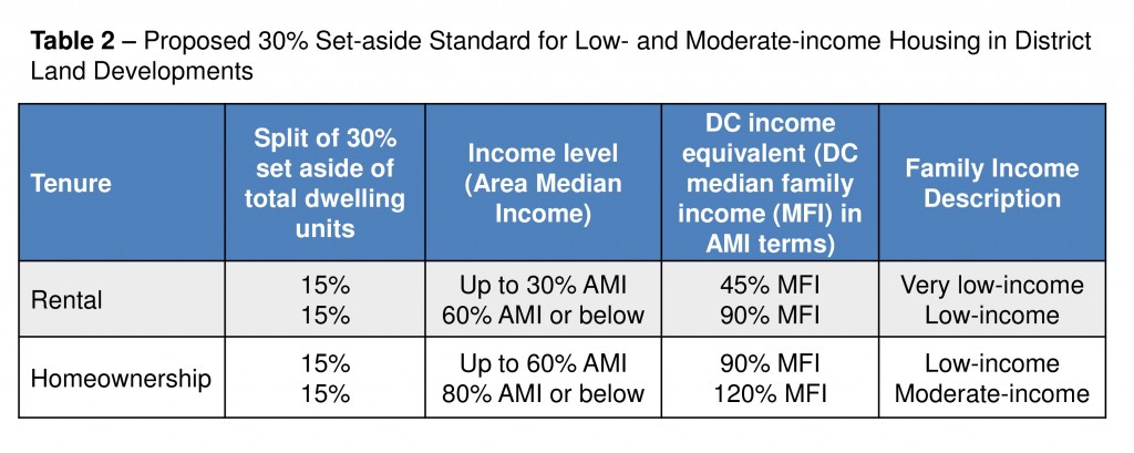
Under DMPED’s current leadership, commitment to affordable housing in solicitations for public land dispositions has steeply declined. DMPED no longer asks for a specific percent of affordable housing or specific income levels. Instead, DMPED asks that proposals comply with or exceed the Inclusionary Zoning (IZ) law, which is already required for most residential development. IZ sets a minimum of 8-10 set aside at 50-80% AMI, with most income targeting at 80% AMI. To compensate, developments receive a 20% bonus density. Given the city can (and used to) leverage the value of its own land to subsidize housing, we should expect much more from public land deals. We recommend that DMPED restore the earlier practice of to asking for a 20-30% set aside with income targeting at the 30% AMI, 60% AMI and no more than 80% AMI income levels. (See tables 1 & 2 below).
This drop off in affordable housing in public land dispositions as a priority is particularly surprising given the attention the administration has put on renewing efforts to preserve and create more affordable housing. Public lands are an important tool for creating new affordable housing that the administration should not abandon now. We ask the council to ensure we are making the most of the unique opportunity to leverage the value of the District’s land to create more affordable housing through the public land disposition process. Public land disposition and development requests should clearly ask for and prioritize proposals that offer substantial amounts of affordable housing, including units affordable to those earning 30 percent AMI. As was the practice in the past, we ask that requests specify the city is seeking 20 percent to 30 percent of the total number of residential units affordable at 30 percent and 60 percent AMI for rentals, and up to 80 percent AMI for ownership. We suggest table 2, below, as a model. In addition, we ask that DMPED better coordinate with other agencies to pool resources to ensure the production of housing affordable at deeply affordable levels as a part of larger mixed income or all affordable development.
DHCD – support $100 million to affordable housing, ensure IZ & ADUs have support they need
Regarding DHCD’s budget, first and foremost, we want to express our support for the $100 million commitment to affordable housing, with $87 million going to the Housing Production Trust Fund. We commend the Mayor for this commitment and ask the Council to support this. These funds are critically important to addressing our city’s escalating housing prices that are burdening a large share of D.C. households with higher and higher housing costs.
Inclusionary Zoning & affordable dwelling unit management
IZ administration has experienced significant problems in the start up phase. DHCD has indicated that is making headway addressing these significant challenges. DHCD will propose revisions to overly cumbersome administrative regulations, which should improve the process. DHCD has worked with Office of Planning and the Zoning Commission to resolve conflicts with FHA mortgage lending standards. DHCD has solicited for additional assistance to implement IZ and Affordable Dwelling Unit (ADU) programs. These are all important steps to addressing the major administrative challenges IZ implementation has encountered. We remain concerned that the office responsible for administering IZ and ADUs is understaffed. We suggest that at a minimum, and new Capital City Fellow be added to their small team.
I want to thank Director Michael Kelly and his staff for their openness and responsiveness to us.
Thanks also to Chairman Bowser’s keen interest in ensure these programs work, and affordable housing opportunities are increased.
Thank you for your consideration.
Sincerely,
Cheryl Cort
Policy Director

Testimony before Martin Grossman, Director of the Office of Zoning and Administrative Hearings in Opposition to Special Exception Request for S-2863, Costco Wholesale Corporation
Dear Hearing Examiner Grossman:
Please accept these comments on behalf of the Coalition for Smarter Growth. Our non-profit organization works to ensure that transportation and development decisions in the Washington, D.C. region, including the Maryland suburbs, accommodate growth while revitalizing communities, providing more housing and travel choices, and conserving our natural and historic areas.
We want to express our opposition to the Special Exception request for the Costco automobile filling station – a large scale gas station which will attract vehicle trips from outside the local area. We believe this proposal is wholly inconsistent with the 2012 Wheaton CBD and Vicinity Sector Plan, and antithetical to the goal of promoting transit-oriented, pedestrian-friendly development within one half mile of a Metro station. The Wheaton Sector Plan area not only offers high quality Metrorail service, but also extensive bus service and a planned rapid transit service. This concentration of transit services will increase the share of trips made by transit, encourage more walking, and reduce how much people drive in the area.
As a regional organization, we advocate for well-designed transit- and pedestrian-oriented development which focuses more housing and commercial activities within an easy walk of Metro stations and other high quality transit services and historic downtowns. We seek to mitigate existing automobile-oriented uses in transit districts, and prohibit new ones. Reducing auto-oriented uses and their impacts are important to fostering a public realm and private development that better cater to pedestrians rather than prioritize the movement of motor vehicles. Uses such as gas stations, automobile repair services, drive thrus, and similar uses that attract motor vehicular traffic and encourage automobile-oriented designs such as additional driveways, wider driveways, surface parking, and curb cuts should be minimized, reduced, and in some cases, prohibited in transit districts like the Wheaton Sector Plan area. The proposed, a high volume gas station, is an unnecessary new auto-oriented use that would detract from the county’s and our efforts to create a more pedestrian-friendly environment around the Metro station.
The Plan specifically identifies the existing “auto-oriented uses” of the area as one of the key issues to be addressed through the implementation of the Sector Plan. The addition of a large scale gas station would compound the “auto-oriented uses” problem identified in the Sector Plan. We recognize that the site of the gas station is on the outer part of the mall property and Plan boundary. Yet we find the proposed use not a neutral use related to our goals to improve the pedestrian environment, but rather a use that actively degrades the pedestrian environment and works against Sector Plan goals. With such a large scale gas station, additional vehicle trips will be attracted to the transit district from outside the local area simply for the purpose of refueling vehicles with cheaper gasoline. This regional automobile service use contradicts the Sector Plan’s and our goals to reduce vehicle miles traveled. Introduction of a new large scale gas station would directly oppose the Plan’s guidance to:
“Provide better pedestrian connectivity and support safe, secure, and appealing street level activity” (p. 25)
In an area like the Wheaton Sector Plan area, we have often found that the transition from auto-oriented land uses take time, but can be phased in to create more transit-oriented and pedestrian-friendly development. The Wheaton Sector Plan accommodates the existing auto-oriented regional mall surrounded by surface parking, but seeks to manage the negative impacts on pedestrians but proposing pedestrian access improvements, pedestrian-oriented street design changes, and encouragement of redevelopment to a more pedestrian-friendly design. Preventing new uses that would further degrade the transit district is also an important part of progressing towards a more pedestrian-friendly Wheaton Sector Plan and Metro station area. The large scale gas station would degrade the pedestrian environment by attracting additional automobile trips to the area and force more automobile-oriented designs for public rights-of-way to accommodate this auto-oriented use. Preventing this kind of use also promotes our overall goals to support greater use of transit, and build safe, walkable places, especially around major transit hubs.
For all of these reasons, the Coalition for Smarter Growth urges denial of the Special Exception application for the Costco automobile filling station.
Thank you for your consideration.
Sincerely,
Cheryl Cort
Policy Director