The Virginia Department of Transportation’s (“VDOT”) own traffic modeling data reveal that the proposed Bi-County Parkway (“BCP”) would worsen, not relieve, traffic congestion. The same model shows that the comprehensive alternative offered by our coalition (termed the “Substitute Vision” by VDOT) will better address congestion in the study area, and better serve the dominant need for east-west traffic capacity—now and in the future.
Category: Virginia

Columbia Pike Streetcar Fact Sheet
The Coalition for Smarter Growth supports the streetcar as a key element of bringing new life to Columbia Pike. The streetcar is a good idea. Here’s why:
Economic Development: Streetcars outperform regular buses in spurring economic development, a key need in Columbia Pike. The permanence of streetcar infrastructure has already boosted developers’ confidence in investing in the corridor.
In Arlington, state wants to develop and build over I-66 in Rosslyn, East Falls Church Metro

The proposed area in Rosslyn where Virginia is asking for possible development suggestions. The area in pink is the main area, the areas in light green are secondary possibilities.
Air rights are rapidly becoming a hot topic in Northern Virginia. Some heavy-hitters in Fairfax are pushing for development over the Silver Line stations on the Dulles Toll Road. And on Wednesday, Gov. Bob McDonnell (R) announced that the state is seeking ideas from private developers about building over Interstate 66 in Rosslyn, and over the tracks leading to the East Falls Church Metro station, both in Arlington County.
The “Request for Information” by the state suggests the area of I-66 immediately adjacent to Arlington Gateway Park, or the “Rosslyn tunnel” as the radio traffic reporters call it, might be a good place to develop, and that the stretches of I-66 to the east of that area, and to the west of the park/tunnel, would also be possibilities. This would appear to be about three blocks from the Rosslyn Metro station, which the Request calls “the northern and eastern edges of the Rosslyn metro area.” In East Falls Church, which Arlington did an extensive plan for in 2011, the Request suggests building directly over the tracks on the east side of the Metro station, and then also in the south parking lot immediately adjacent.
“By leasing airspace above certain transportation facilities owned by the Commonwealth,” McDonnell said in a press release, “we can better utilize our existing infrastructure to generate additional revenues to fund future transportation improvements, while at the same time attracting new jobs and economic development.”
In addition to devising a comprehensive plan for East Falls Church, Arlington has also begun working on a plan for Rosslyn. County Board Chairman Walter Tejada said in the governor’s press release that “We will ensure that any potential transit-orientated development using these air rights in Arlington County is consistent with our community’s vision and is consistent with the county’s land use and transportation plans.”

The proposed redevelopment area for the East Falls Church Metro station, with the prime area in pink, and the secondary proposed area in light blue.
Fairfax Supervisor Pat Herrity (R-Springfield), one of the big supporters of air rights along the Metro stations being built in Fairfax, applauded the move by the state’s Office of Transportation Public-Private Partnerships, in conjunction with the state Department of Transportation and Metro.
“Governor McDonnell, Secretary of Transportation Connaughton, and the partners responsible for this RFI,” Herrity said, “obviously see the value in air rights with their statement today, and see their feasibility in Northern Virginia. We should be exploring similar options along the Dulles Toll Road corridor.”
One problem that has been raised with sale of air rights, and likely becomes relevant again, is that there is no shortage of existing office space in Northern Virginia, and the cost of building over an existing Metro station or busy highway is, well, high.
Stewart Schwartz of the Coalition for Smarter Growth raised the question for Rosslyn about “whether they are getting close enough to buildout that air rights development might not have the effect of undermining existing plans and development being proposed.” At East Falls Church, he wondered how air rights would fit with Arlington’s new plan for the area, and whether it would again raise the issue of widening I-66, which Arlington has fought fiercely, and successfully, for many years.
There’s also the question of what this potential opportunity might do to the market for Tysons Corner. Developers are being recruited there on the premise they’ll be near Metro stations. Might this give those developers another option, without the tax burden imposed on businesses around the Silver Line, and hurt Tysons’ future growth? The future is wide open.
Bob Brosnan, Arlington’s director of community planning, housing and development, said that the state has promised to work with Arlington and abide by the plans the county has established for Rosslyn and East Falls Church. “Rosslyn does have a lot of development potential,” he said, but added, “we had never thought of doing development over the highway. Who knows what might develop?” Similarly, at East Falls Church, “the idea of going over 66 is nothing we had talked about before. If developers think there is a market, then we would be willing to entertain whatever proposals they have.” He thought development around either station could lead to better connections with the surrounding neighborhoods.
Sean Connaughton, the secretary of transportation, told me, “these two sites came up as maybe perfect projects for us in pursuing air rights. And if we’re successful here, we would for other places not only in Northern Virginia but throughout the Commonwealth, use air rights to spark development and use the money to defray the cost of transportation.” He did not think the development possibilities would take away from Tysons because they are different types of areas, Tysons already having two large existing shopping malls (and no parking around the new stations), Arlington being more commercial at Rosslyn and residential at East Falls Church.
Photos courtesy of the Office of Transportation Public Private Partnerships.
Click here to read the original story>>
Public weighs in on how to improve NoVa commuting
 FAIRFAX, Va. – At the first of two Northern Virginia Transportation Authority public hearings Thursday, about 100 people showed up at Fairfax City’s city hall to discuss the best way to improve commutes.
Specifically, the NVTA wanted to get advice on how to spend about $192.5 million that will come from new taxes in Virginia Gov. Bob McDonnell’s transportation package, which takes effect July 1.
“While we want to work quickly, we also want to make sure we spend these dollars wisely,” said NVTA Chairman Martin Nohe, who also serves on the Prince William County Board of Supervisors.
The authority released a long list of projects, broken down into six corridors, with detailed descriptions of costs and congestion relief projections.
Delegate Jim LeMunyon, a Republican who represents part of Fairfax and Loudoun counties, handed out maps to NVTA members with red, yellow and green lines to describe congestion in Northern Virginia.
“In my view, the priority of the authority is to get the red off the map. It’s as simple as that,” he said.
But Stewart Schwartz, executive director of the Coalition for Smarter Growth, testified that LeMunyon’s approach is too focused on cars and not enough on transit.
“The misguided approach of just trying to get the red out by widening roads and adding interchanges is only going to squander our tax dollars,” he said.
Schwartz advocates policies that promote sustainable communities where people can eat, work and play in one spot. He urged NVTA members to fund mass transit options that will solve congestion problems in the long term.
Several citizens who testified seemed to agree with this approach.
“Move the rail projects to the top of the list. Give them the highest priority because they’ll do the most good for the most people,” said Alexandria resident Gail Parker.
“When you’re looking at projects that are efficient, an automobile that’s only carrying one person is not a very efficient mode of transportation,” said Fairfax City resident Douglas Stewart.
Schwartz says constantly widening roads also could convince drivers to abandon carpools and go back to single-occupancy vehicles, which he says is a bad idea.
However, several residents also pointed to Route 28 projects as a good use of transportation dollars.
“Route 28 connects western Prince William to Fairfax and Loudoun and there are several shovel-ready projects that are just awaiting money and could help with congestion relief,” said Nohe.
Kerry O’Brien of Fairfax County is familiar with traffic on the roadway.
“Route 28 is severely congested during the rush hours now. Relief is needed now. It’s not needed in 2035, it’s needed now,” he said.
Jeff Fairfield of the Route 28 Station – South Study Working Group applauded the efforts.
“These projects are shovel-ready. The final designs are ready. The right-of-way has been secured. The construction contracts are ready to go,” he said.
But Jeanine Lawson of Prince William County urged caution.
“I ask you to closely scrutinize the project for widening Route 28 from Linton Hall Road to Fitzwater Drive. That road is on the border of Fauquier County, which isn’t covered in this tax, so I question why you’d do it. The money would be better spent in the Yorkshire section,” she said.
Lawson was referring to a particularly congested stretch of Route 28 on the Prince William County and Fairfax County border between Manassas and Centreville.
Nohe believes both the Linton Hall Road and Yorkshire projects could get money this year.
Currently, the list contains 12 road and 21 transit projects. LeMunyon wants NVTA members to reduce the list to three or four, but Nohe tells WTOP he thinks the final approval list will have 10 to 15 projects.
The NVTA will hold a second public hearing on July 24 at 6 p.m. at Fairfax City’s city hall, then hold a meeting where a few projects could get the green light.
Two more open houses will be held next week:
- Fairfax County
Date: June 26th
Time: 7:00 p.m.
Location: Fairfax County Government Center, 12000 Government Center Parkway, Rooms 4/5, Fairfax, Virginia. - Arlington County
Date: June 27, 2013
Time: 6:00 pm
Location: Arlington County Board Room 300, 2100 Clarendon Boulevard Arlington, Virginia 22201
Photo courtesy of WTOP/Ari Ashe.
Click here to read the original story>>
Public Gets First Input On Transportation Bill Projects
 Members of the public from Loudoun, Arlington, Fairfax and Prince William counties got their first chance to speak to the full board of the Northern Virginia Transportation Authority Thursday night in a public hearing discussing the projects that could receive funding from the General Assembly’s transportation bill that passed earlier this year.
Twenty-two people, including legislators, representatives of local advocacy groups and individuals giving their opinions, went before the board, and dozens more reviewed the almost 50 projects the NVTA is considering. The NVTA’s priority is finalizing a list of projects that will receive funding for FY14, when there is expected to be $190 million available.
NVTA Chairman Martin Nohe, the Coles District Supervisor in Prince William County, gave a 30-minute presentation before anyone spoke, explaining what the NVTA is and how board members plan to implement the funding. $1.6 billion is expect to come to Northern Virginia over the next six years from HB2313, 70 percent of which will be dispersed by the NVTA and 30 percent going directly to each locality: the four counties and the cities of Manassas, Manassas Park, Falls Church and Alexandria.
The money is intended, essentially, to relieve the high levels of congestion that have plagued the area for years, and only figure to get worse. The main bone of contention among those who spoke was the best way to go about doing that.
“There’s a lack of quantitative information right now to evaluate projects with different modes and different types,” Del. Jim LeMunyon (R-67) who was the first to speak, said. “For every million dollars we spend, how many hours are we putting back into the lives of Northern Virginians? We need to know that.”
Residents in Prince William and Loudoun counties almost unanimously applauded the NVTA’s to fund the widening of several segments of Rt. 28 in Loudoun, Fairfax and Prince William counties.
The projects proposed for FY14 funding are “hot spot” improvements between Sterling Boulevard and the Dulles Toll Road in Loudoun, expanding from two lanes to a four-lane divided roadway from Linton Hall to Fitzwater Drive in Prince William, and widening from three to four lanes southbound between the Dulles Toll Road and Rt. 50 and northbound from McLearen Road to the Dulles Toll Road in Fairfax County.
“I’m here to commend your decision to include the Rt. 28 hot spot improvements,” Jeff Fairfield, speaking on behalf of the Rt. 28 Tax District Landowners Advisory Board, said. “These improvements will alleviate congestion. There’s been a tremendous improvement on removing traffic lights, yet we now experience congestion due to a lack of lane capacity.”
“Rt. 28 relief is needed now,” Gary O’Brien of Manassas said. “There are currently several disconnected projects. What it needs is more transportation capacity, right through the system. Try to consolidate the little plans into a larger system.”
Arlington County Supervisor Chris Zimmerman, the chairman of the Project Implementation working group, said the list of projects proposed for funding was built from existing transportation plans, such as the NVTA’s TransAction 2040, and are closest to “shovel-ready.”
“Our aim has been to, No. 1, follow the law” Zimmerman said. “We began by reviewing what the statutes require of us. In developing criteria, that was first and foremost. It has been our intention to use objective criteria and quantifiable criteria to the greatest degree possible. That is what we have been trying to accomplish.
“Many of the projects, by their nature, will take multiple years to do and have multiple parts. It’s a very complex network; there isn’t a silver bullet. It will take a lot of fixing in different places.”
Many Prince William County residents spoke against potential funding of the Bi-County Parkway, a controversial transportation project stretching from I-95 to Rt. 50 in Loudoun, but the project is not among those included for FY14 funding or on the Six-Year Plan.
Perhaps the most scrutinized debate will be how many funds are devoted to transit projects, pedestrian or bicycle projects, and how much will simply be devoted to increasing capacity on the roads network.
“In a great metropolitan area, you cannot ‘get the red out,’” Stewart Schwartz, the executive director of the Coalition for Smarter Growth, said about relieving intense traffic jams. “We have to account for induced traffic. For the peak-hour commute, there’s nothing better than high-capacity transit. I urge you to resist a return to the old approach, which didn’t work, and focused on a transit-oriented, walkable bikeable future that we need to have.”
The NVTA will hold another public hearing July 24 before deciding upon the final FY14 list at 6 p.m. Wednesday, July 24, at Fairfax City Hall. The public comment period before the Project Implementation’s next working group will close next week. The form, and submittal information, can be found here.
Photo courtesy of Leesburg Today.
Six-Year Improvement Program: a Blueprint for Failure
With the adoption of the new Six-Year Improvement Program, the details of Governor Bob McDonnell’s transportation priorities plan are coming into clearer focus. There are some worthy elements to the plan but glaring deficiencies guarantee that Virginia will see minimal benefit from the billions of dollars dedicated to new construction.
On the positive side of the ledger, it is heartening to see that Virginia will get serious about meeting its statutory maintenance obligations. The Virginia Department of Transportation (VDOT) will spend an estimated $2.3 billion over the next six years to rehabilitate aging bridges. Roughly one in eleven bridges in the state is rated “structurally deficient.” (See “Bad Bridges” for details). VDOT also will dedicate 25% of its formula revenues to repairing deteriorating pavement on state interstates and primary roads. (It’s not clear from published reports, however, whether this work will address the aging sub-structure of these roads, which account for much of the deterioration.)
Second, VDOT will apply 5% of formula revenue to “smart roadway” projects, which will utilize sensors, video, wireless communication, artificial intelligence and other advanced technologies to do a better job of synchronizing traffic signals, clearing accidents and communicating information to drivers. If executed properly, these investments can increase the capacity of existing traffic arteries at significantly lower cost than constructing more lanes.
On the other hand…. Stewart Schwartz, executive director for the Coalition for Smarter Growth, sums up the negatives in a press release issued yesterday after the Commonwealth Transportation Board meeting:
“We are shocked by the lack of discussion of the spending priorities in the Six-Year Plan, by the failure to tie the program to specific policy goals, and the assumption that simply adding road capacity will solve our transportation problems. The plan includes a number of wasteful mega-projects that have been strongly criticized as unnecessary including Route 460 ($1.4 billion), the Coalfields Expressway ($2.8 billion), Charlottesville Bypass ($244 million), N-S Corridor ($1 billion plus), and a long range $11.4 billion plan for I-81.
The CTB doesn’t understand the benefits of more efficient land use – of cities, towns, and compact transit-oriented development – along with transportation demand management programs (carpooling, telecommuting etc), that reduce driving demand. They don’t understand changing demographics and market demand that have led to big declines in vehicle miles traveled. The plan includes just 9% of the total for transit even though 69% of the state population lives in the Urban Crescent.
In short, we believe this program will be remembered for squandering billions of tax dollars while making Virginia’s patterns of development less efficient, more oil dependent and less competitive.”
I couldn’t have said it better. My only point of difference with Stewart is that I have no faith that the extra $500 million allocated to rail and public transportation (bringing the total to $2.9 billion) will be spent any more effectively than the money dedicated to roads. When funding decisions are based upon politics rather than objective Return on Investment analysis, the potential exists for rail and public transit projects to be every bit as wasteful as road projects.
Virginia’s decision-making process for allocating transportation dollars is a mess. It is bureaucratic, cumbersome and lengthy. Once projects make it into the pipeline, they rarely get re-evaluated in the light of changing travel trends or market conditions. The CTB exercises no independent review over the priorities handed down by the McDonnell administration. Functioning as regional advocates and conduits of information to the administration, CTB representatives do their most important work behind the scenes. By the time projects are formally reviewed during CTB meetings, the decisions have already been made. Additionally, there are major transparency issues associated with Public Private Partnership mega-projects. The need for confidentiality when the state negotiates with private-sector partners conflicts with the need for public disclosure before the final deal has been struck.
The McDonnell administration has made no effort whatsoever to address these process issues. It has made no effort to re-evaluate projects in the funding pipeline in the light of new demographic, travel and development trends. And it has made no effort to better align transportation planning and land-use planning. The entire approach has been marked by spending as much money as possible to build as many projects as possible. Bottom line: The McDonnell administration has borrowed billions of dollars and raised our taxes in order to pour more money into a broken system.
Photo courtesy of James Bacon.
VDOT to increase spending on deficient bridges
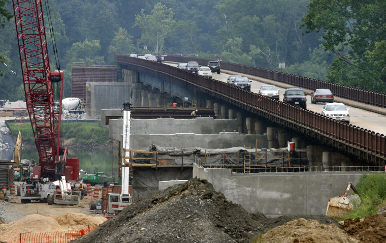
VDOT will spend nearly $2.3 billion to upgrade the state’s bridges over the next six years.
“We’re going to spend $564 million in additional state money on bridge reconstruction and rehabilitation,” said state Transportation Secretary Sean T. Connaughton. “This isn’t just about infrastructure. This is about ensuring the public safety.”
The goal is to make sure the percentage of structurally deficient bridges remains less than 8 percent of the state’s nearly 21,000 bridges and culverts.
“There’s a large backlog of bridge maintenance projects that we’re now going to be able to get to,” Connaughton said at the Commonwealth Transportation Board meeting Wednesday in Richmond.
This year, 7.5 percent of Virginia bridges were rated structurally deficient, the Virginia Department of Transportation said.
Nationally, 11 percent of 607,000 road bridges were considered in poor repair, according to figures from the Federal Highway Administration. The average U.S. bridge is 42 years old.
VDOT says that bridges slated to be replaced as structurally deficient in the Richmond region include those carrying Interstate 64 over Airport Drive in Henrico County, Interstate 195 over the Powhite Parkway in Richmond, U.S. 1 over railroad tracks at Bellwood in Chesterfield County, and state Route 13 over Sallee Creek in Powhatan County.
The funds for accelerated bridge work are part of the state’s $17.6 billion allocation for transportation programs for the fiscal year that begins July 1 and continues through the fiscal year that ends June 2019.
The six-year transportation program, including new funding sources for Northern Virginia and Hampton Roads, is $6.2 billion larger than last year’s approved plan, a 54 percent increase. The state Transportation Board approved the new six-year program Wednesday.
The funding increase largely springs from revenue the General Assembly provided this year, the first significant infusion of money into the state’s cash-strapped transportation system since 1986.
Not everyone was pleased with the spending plan.
“This program will be remembered for squandering billions of tax dollars while making Virginia’s patterns of development less efficient, more oil dependent and less competitive,” said Stewart Schwartz, executive director of the Coalition for Smarter Growth.
The plan includes a number of “wasteful mega-projects that have been strongly criticized as unnecessary,” Schwartz said, citing $1.4 billion for the new U.S. 460; $244 million for the Charlottesville Bypass project; the $1 billion-plus North-South Corridor highway in Northern Virginia; and the $2.8 billion Coalfields Expressway in Southwest Virginia.
“We are shocked by the lack of discussion of the spending priorities in the six-year plan, by the failure to tie the program to specific policy goals, and the assumption that simply adding road capacity will solve our transportation problems,” Schwartz said.
The May 23 collapse of an Interstate 5 bridge in Mount Vernon, Wash., has drawn national attention on the issue of bridge safety. In the I-5 incident, a 160-foot span of the four-lane bridge collapsed into the Skagit River after a tractor-trailer with an oversized semitrailer struck the span’s overhead truss structure.
To eliminate the nation’s deficient bridge backlog by 2028, the U.S. needs to invest $20.5 billion annually, though only $12.8 billion is being spent currently, the American Society of Civil Engineers said in its 2013 Report Card for America’s Infrastructure.
According to the American Association of State Highway and Transportation Officials, being classified as structurally deficient does not mean a bridge is unsafe.
If a Virginia bridge’s structural rating sinks too low, state highway officials post a lower weight limit on it and increase its frequency of inspections. In the worst case, VDOT closes bridges in poor condition.
Photo courtesy of P. Kevin Morley.
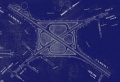
Va. transportation board approves study that includes Bi-County Parkway
RICHMOND — A state transportation board Wednesday advanced plans for a controversial project to build a parkway connecting Prince William and Loudoun counties.
The Commonwealth Transportation Board, in a 15 to 1 vote, endorsed a master-plan study that looked at potential improvements along the state’s North-South Corridor, a 45-mile route connecting the two Northern Virginia counties.
The vote was denounced by opponents of the Bi-County Parkway, who said board’s decision is a sign that the state is moving forward with the 10-mile road, which would skirt Civil War sites to connect I-66 in Prince William with Route 50 in Loudoun.
Board member W. Sheppard Miller III, of Virginia Beach, voted against moving forward, saying the board’s resolution did not adequately rule out toll roads, which he opposes.
A total of 15 people appeared before the board to comment, and several of them urged Virginia Department of Transportation (VDOT) officials to delay the adoption of the corridor study, saying that the state has not been transparent about its plans.
“This impacts tens of thousands who are unaware,” said Tom Thompson, who lives near the site of the proposed parkway.
Gary Garczynski, who lives in Woodbridge and represents the board’s Northern Virginia district, said the vote was a small step in a years-long process for the parkway.
“It’s not a foregone conclusion, and I regret to say that a lot of people think it is,” Garczynski said. “From my perspective, that’s just not true. We have a long way to go.”
The North-South corridor is one of 12 designated regions in which state transportation funding priorities are established. The improvements, including the Bi-County Parkway, are designed to improve traffic flow, spur economic development and provide better access to Dulles International Airport, supporters say.
Del. Timothy D. Hugo, a Republican Party leader who represents parts of Fairfax and Prince William counties, was among those who attended the meeting to object to the proposed road.
The board has “created a firestorm. . . . The rationale provided by VDOT [for the parkway] changes every time,” Hugo said. “These people deserve a straight answer.”
Residents say they worry about increased traffic and the fact that the parkway would run through a protected rural area with a rich Civil War history.
The board’s vote Wednesday came after a month’s delay. Concerns were raised by Rep. Frank R. Wolf (R-Va.), who wrote a letter to Gov. Robert F. McDonnell (R), to say that the state’s process lacked transparency and that more public input was needed. Six Republican state legislators, led by Hugo, have announced that they oppose the road and the state’s handling of the process.
Stewart Schwartz, president of the Coalition for Smarter Growth, has questioned whether a plan for north-south improvements is necessary.
“You started with a conclusion and went backwards,” he said of the adopted study. ““We will look back and realize that we have gained no ground and squandered billions.”
STATEMENT: Virginia Commonwealth Transportation Board Approval of $17.6 Billion Six-Year Capital Spending Program: A Road to Ruin?
Statement on Virginia Commonwealth Transportation Board Approval of $17.6 Billion Six-Year Capital Spending Program
A Road to Ruin?
Today with no debate, the appointed Commonwealth Transportation Board approved the largest transportation spending program in Virginia history, $17.6 billion in capital spending.
“We are shocked by the lack of discussion of the spending priorities in the Six-Year Plan, by the failure to tie the program to specific policy goals, and the assumption that simply adding road capacity will solve our transportation problems. The plan includes a number of wasteful mega-projects that have been strongly criticized as unnecessary including Route 460 ($1.4 billion), the Coalfields Expressway ($2.8 billion), Charlottesville Bypass ($244 million), N-S Corridor ($1 billion plus), and a long range $11.4 billion plan for I-81.
The CTB doesn’t understand the benefits of more efficient land use – of cities, towns, and compact transit-oriented development — along with transportation demand management programs (carpooling, telecommuting, etc.) that reduce driving demand. They don’t understand changing demographics and market demand that have led to big declines in vehicle miles traveled. The plan includes just 9% of the total for transit even though 69% of the state population lives in the Urban Crescent.
In short, we believe this program will be remembered for squandering billions of tax dollars while making Virginia’s patterns of development less efficient, more oil dependent, and less competitive.”
Stewart Schwartz, Executive Director
About the Coalition for Smarter Growth
The Coalition for Smarter Growth is the leading organization in the Washington D.C. region dedicated to making the case for smart growth. Our mission is to promote walkable, inclusive, and transit-oriented communities, and the land use and transportation policies needed to make those communities flourish. To learn more, visit the Coalition’s website at www.smartergrowth.net.
###
Preservation Virginia lists land slotted for Tri-County Parkway as ‘endangered’
Historic Civil War parkland slotted for a controversial new parkway that would connect the counties of Prince William and Loudoun has made the “endangered” list of one of the oldest non-profit preservation organizations in the country.
Preservation Virginia, founded in 1889, focuses on the preservation of historic sites around the state, including Jamestown and the Cape Henry Lighthouse in Virginia Beach. For the first time, the group included land slated for the proposed Tri-County Parkway, a 10-mile, four-lane thoroughfare that would connect I-66 in Prince William with Route 50 in Loudoun, on its list of “most endangered” sites for 2013.
Part of the parkway, which has drawn increased scrutiny in recent weeks, would run through historic Manassas Battlefield land and rural Prince William.
“The Tri-County Parkway would run directly past the August 28, 1862 position of the right flank of Confederate troops led by Stonewall Jackson and the left flank of the Union General Pope’s troops, taking up to 20-35 acres of land from the national park and historic district,” the group said on its Web site.
“Opponents of the highway…believe that it would negatively impact the national park and historic district and predict that the parkway and connecting roads will open up rural land in Prince William … and Loudoun County.”
The group joins a chorus of preservation advocacy groups raising concerns about the project, including the National Trust for Historic Preservation, National Parks Conservation Association, Piedmont Environmental Council, Coalition for Smarter Growth, and Southern Environmental Law Center.
The administration of Gov. Robert F. McDonnell (R) and the business community in Prince William and Loudoun believe the road is vital to the success of the fast-growing region. Supporters say the parkway — which could eventually connect farther east to Interstate 95 — would create jobs and drive economic development in the area, ease congestion and provide a key connection to Dulles International Airport and between two rapidly growing counties.
Elizabeth Kostelny, the executive director of Preservation Virginia, said that the organization is interested in the project in part because the National Park Service has pushed for assurance that if the parkway is built, Route 29 through the battlefield would be closed at Route 234 and a bypass around the park would be built.
“We’re not opposing it outright,” Kostelny said of the Tri-County Parkway. “We remain concerned about the traffic through the Manassas battlefield [and] having assurances those roads will be closed to commuter traffic.”
The Prince William Board of County Supervisors recently delayed a vote on Prince William’s state transportation priorities due to an outcry about the road. The parkway proposal has long had the support of both Prince William and Loudoun supervisors.
Prince William Board Chairman Corey A. Stewart (R-At Large) said in an interview that the board’s delay does not mean that supervisors plan to pull their support. He also said that despite setback and opposition, he believes the proposed parkway will move forward.
“I think they will be successful,” he said of the state’s plans for the road. “The reason is this … we have two of the fastest growing counties in the United States that do not have adequate connections to each other.”
Despite opposition in recent weeks — including from six state area Republican legislators and U.S. Rep. Frank R. Wolf (R-Va.) — state officials say they plan to press forward and hope to explain their plans for the parkway more clearly and how it would benefit residents.