Category: Testimony & Letters

Testimony before The Hon. Andrea Harrison, Chair, Prince George’s County Council Re: Support for CB-20-2013: Expedited Transit-Oriented Development

Please accept these comments on behalf of the Coalition for Smarter Growth. Our organization works to
ensure that transportation and development decisions in the Washington, D.C. region, including the
Maryland suburbs, accommodate growth while revitalizing communities, providing more housing and travel
choices, and conserving our natural and historic areas.

We wish to express our support for CB-20-2013, which is an important step to reducing an institutional
barrier to attracting new investment at Metro stations. CB 20 offers a public process that gives greater
predictably to the review of development applications while also preserving essential public accountability.

We ask the Council also consider creating an evaluation mechanism in the bill so that its performance can be
regularly assessed and reported out to the Council, Planning Board and public. This bill’s expedited
development review process, along with other incentives for TOD, should be regularly assessed so that the
County can fine tune incentives and procedures that are most effective at achieving the goal of quality
transit-oriented development.

While we believe CB 20 will be helpful in encouraging more quality transit-oriented development
applications, we suggest that this does not substitute for rationalizing and reducing the complexity of the
zoning ordinance. We urge the Council to pursue the longer-term and systematic recommendations of the
2009 report: Prince George’s County Zoning Ordinance and Subdivision Regulations Streamlining the
Development Review Process.

Thank you for your consideration.

Sincerely,

Cheryl Cort
Policy Director

Testimony before the Hon. Muriel Bowser, Chair of the Committee on Economic Development and Housing re: FY 2014 Budget Oversight for DMPED and DHCD

Please accept these comments on behalf of the Coalition for Smarter Growth. We are a regional organization based in the District of Columbia focused on ensuring transportation and development decisions are made with genuine community involvement and accommodate growth while revitalizing communities, providing more housing and travel choices, and conserving our natural and historic areas.

DMPED should recommit to leveraging public land dispositions for affordable housing

We are greatly disappointed in DMPED’s reduced expectations for affordable housing in new public land dispositions. Given the increasing challenge of housing affordable to our residents, we urge the Council to ensure DMPED recommit to leveraging public land dispositions for affordable housing, including for very low income households. In our 2012 report, Public Land for Public Good, we show that the District has and can do great things with its city-owned land. We are disappointed that DMPED is departing from the practice of the past decade to ask for 20-30 percent of affordable housing in public land dispositions affordable to households earning 30%, 50%, 60% and 80% Area Median Income (AMI). We are also surprised that the Mayor’s Housing Task Force dropped any recommendation to make the most of public land sales for affordable housing and sent this issue to the future study list.

Under DMPED’s current leadership, commitment to affordable housing in solicitations for public land dispositions has steeply declined. DMPED no longer asks for a specific percent of affordable housing or specific income levels. Instead, DMPED asks that proposals comply with or exceed the Inclusionary Zoning (IZ) law, which is already required for most residential development. IZ sets a minimum of 8-10 set aside at 50-80% AMI, with most income targeting at 80% AMI. To compensate, developments receive a 20% bonus density. Given the city can (and used to) leverage the value of its own land to subsidize housing, we should expect much more from public land deals. We recommend that DMPED restore the earlier practice of to asking for a 20-30% set aside with income targeting at the 30% AMI, 60% AMI and no more than 80% AMI income levels. (See tables 1 & 2 below).

This drop off in affordable housing in public land dispositions as a priority is particularly surprising given the attention the administration has put on renewing efforts to preserve and create more affordable housing. Public lands are an important tool for creating new affordable housing that the administration should not abandon now. We ask the council to ensure we are making the most of the unique opportunity to leverage the value of the District’s land to create more affordable housing through the public land disposition process. Public land disposition and development requests should clearly ask for and prioritize proposals that offer substantial amounts of affordable housing, including units affordable to those earning 30 percent AMI. As was the practice in the past, we ask that requests specify the city is seeking 20 percent to 30 percent of the total number of residential units affordable at 30 percent and 60 percent AMI for rentals, and up to 80 percent AMI for ownership. We suggest table 2, below, as a model. In addition, we ask that DMPED better coordinate with other agencies to pool resources to ensure the production of housing affordable at deeply affordable levels as a part of larger mixed income or all affordable development.

DHCD – support $100 million to affordable housing, ensure IZ & ADUs have support they need

Regarding DHCD’s budget, first and foremost, we want to express our support for the $100 million commitment to affordable housing, with $87 million going to the Housing Production Trust Fund. We commend the Mayor for this commitment and ask the Council to support this. These funds are critically important to addressing our city’s escalating housing prices that are burdening a large share of D.C. households with higher and higher housing costs.

Inclusionary Zoning & affordable dwelling unit management

IZ administration has experienced significant problems in the start up phase. DHCD has indicated that is making headway addressing these significant challenges. DHCD will propose revisions to overly cumbersome administrative regulations, which should improve the process. DHCD has worked with Office of Planning and the Zoning Commission to resolve conflicts with FHA mortgage lending standards. DHCD has solicited for additional assistance to implement IZ and Affordable Dwelling Unit (ADU) programs. These are all important steps to addressing the major administrative challenges IZ implementation has encountered. We remain concerned that the office responsible for administering IZ and ADUs is understaffed. We suggest that at a minimum, and new Capital City Fellow be added to their small team.

I want to thank Director Michael Kelly and his staff for their openness and responsiveness to us.

Thanks also to Chairman Bowser’s keen interest in ensure these programs work, and affordable housing opportunities are increased.

Thank you for your consideration.

Sincerely,

Cheryl Cort
Policy Director

Table 1
Table 2

Testimony before Martin Grossman, Director of the Office of Zoning and Administrative Hearings in Opposition to Special Exception Request for S-2863, Costco Wholesale Corporation

Dear Hearing Examiner Grossman:

Please accept these comments on behalf of the Coalition for Smarter Growth. Our non-profit organization works to ensure that transportation and development decisions in the Washington, D.C. region, including the Maryland suburbs, accommodate growth while revitalizing communities, providing more housing and travel choices, and conserving our natural and historic areas.

We want to express our opposition to the Special Exception request for the Costco automobile filling station – a large scale gas station which will attract vehicle trips from outside the local area. We believe this proposal is wholly inconsistent with the 2012 Wheaton CBD and Vicinity Sector Plan, and antithetical to the goal of promoting transit-oriented, pedestrian-friendly development within one half mile of a Metro station. The Wheaton Sector Plan area not only offers high quality Metrorail service, but also extensive bus service and a planned rapid transit service. This concentration of transit services will increase the share of trips made by transit, encourage more walking, and reduce how much people drive in the area.

As a regional organization, we advocate for well-designed transit- and pedestrian-oriented development which focuses more housing and commercial activities within an easy walk of Metro stations and other high quality transit services and historic downtowns. We seek to mitigate existing automobile-oriented uses in transit districts, and prohibit new ones. Reducing auto-oriented uses and their impacts are important to fostering a public realm and private development that better cater to pedestrians rather than prioritize the movement of motor vehicles. Uses such as gas stations, automobile repair services, drive thrus, and similar uses that attract motor vehicular traffic and encourage automobile-oriented designs such as additional driveways, wider driveways, surface parking, and curb cuts should be minimized, reduced, and in some cases, prohibited in transit districts like the Wheaton Sector Plan area. The proposed, a high volume gas station, is an unnecessary new auto-oriented use that would detract from the county’s and our efforts to create a more pedestrian-friendly environment around the Metro station.

The Plan specifically identifies the existing “auto-oriented uses” of the area as one of the key issues to be addressed through the implementation of the Sector Plan. The addition of a large scale gas station would compound the “auto-oriented uses” problem identified in the Sector Plan. We recognize that the site of the gas station is on the outer part of the mall property and Plan boundary. Yet we find the proposed use not a neutral use related to our goals to improve the pedestrian environment, but rather a use that actively degrades the pedestrian environment and works against Sector Plan goals. With such a large scale gas station, additional vehicle trips will be attracted to the transit district from outside the local area simply for the purpose of refueling vehicles with cheaper gasoline. This regional automobile service use  contradicts the Sector Plan’s and our goals to reduce vehicle miles traveled. Introduction of a new large scale gas station would directly oppose the Plan’s guidance to:

“Provide better pedestrian connectivity and support safe, secure, and appealing street level activity” (p. 25)

In an area like the Wheaton Sector Plan area, we have often found that the transition from auto-oriented land uses take time, but can be phased in to create more transit-oriented and pedestrian-friendly development. The Wheaton Sector Plan accommodates the existing auto-oriented regional mall surrounded by surface parking, but seeks to manage the negative impacts on pedestrians but proposing pedestrian access improvements, pedestrian-oriented street design changes, and encouragement of redevelopment to a more pedestrian-friendly design. Preventing new uses that would further degrade the transit district is also an important part of progressing towards a more pedestrian-friendly Wheaton Sector Plan and Metro station area. The large scale gas station would degrade the pedestrian environment by attracting additional automobile trips to the area and force more automobile-oriented designs for public rights-of-way to accommodate this auto-oriented use. Preventing this kind of use also promotes our overall goals to support greater use of transit, and build safe, walkable places, especially around major transit hubs.

For all of these reasons, the Coalition for Smarter Growth urges denial of the Special Exception application for the Costco automobile filling station.

Thank you for your consideration.

Sincerely,

Cheryl Cort
Policy Director

Testimony before the City of Alexandria City Council re: Coordinated Development Districts #21/#22 and Design Standards for Beauregard Small Area Plan

Good afternoon. I am Stewart Schwartz, Executive Director for the Coalition for Smarter Growth.

The Coalition for Smarter Growth closely tracked the planning for the redevelopment of the Beauregard corridor and testified in support of the new plan. We have studied the staff report for the new Coordinated Development Districts in great detail.

Our review of the staff report, community advisory committee reports and other supporting documentation indicates a very high degree of due diligence and analysis. The city has invested significant resources in ensuring all the pieces fit together in this complex rezoning, including the design standards, the staging related to transportation improvements, and the developer commitments to financing public infrastructure and affordable housing. The city also established community advisory committees to collect ongoing input and provide independent recommendations to the staff, Planning Commission and Council.

Mixed-use, mixed-income development in walkable, transit-oriented development offers the best way for our region to grow while managing traffic, increasing access to jobs for all incomes, and reducing energy use and pollution, including greenhouse gas emissions.

Understandably, the key area of ongoing concern has been affordable housing and we understand the concern of existing residents who depend on affordable rents. Entendemos. The Coalition for Smarter Growth has included affordable housing policy as a core component of our work including support for housing trust funds, inclusionary zoning, use of public land, zoning and other tools.

Market rate affordable housing is under pressure and at risk due to the region’s continued population growth and the traffic that is encouraging residents to live closer to jobs and transit. It is this demand to live close to jobs, transit and the core, that has developers like JBG seeking out larger parcels of land with the potential for significant redevelopment, such as the garden apartments within the Beauregard community.

Most of the garden apartments are found in an area that the city included in CDD #4 a number of years ago, which created an incentive for purchase and redevelopment, but without a set-aside or other affordable housing preservation strategies for the area. Given the current situation, CDD #21/#22 offers the best opportunity to secure long-term committed affordable housing and a range of other community benefits.

We are glad that the city conducted a tenant survey to better understand the needs, and that as a result, the city has made adjustments to the affordable housing plan, tenant transition, and associated financing plan, including increasing the number of units for households with incomes at 40% of Area Median Income and below.

The plan’s housing goal and an effective strategy to create 800 long-term committed affordable units are essential. It includes the largest developer contribution ever made to affordable housing in our region – $66 million, and the city’s substantial commitment using tax increment financing. It appears to now be better tailored to the needs identified in the tenant survey with a focus on people earning $15,000 to $65,000 per year, depending on family size. Over 50% of the 800 units will be at 40% AMI and below.

Redevelopment of the garden apartments will happen over many years, providing time for creative affordable housing deals, especially with non-profit housing developers, and other strategies to offer additional committed affordable housing units. Espero que; creo que la Ciudad va a hacer lo que es necesario para ayudar a la communidad con este cambio.

The city has drafted an Affordable Housing Master Plan, which is much needed. We’ve lost too much because of not doing enough in the past. The plan should also be improved with clear numerical goals, dedicated funding, and the city’s priority attention to adopting the policies and programs necessary to more effectively preserve and expand affordable housing. At the same time, the city also needs the tax base from well-planned, competitive transit-oriented redevelopment to create the taxpayer resources necessary for this affordable housing strategy.

In conclusion and weighing the information before you today, we recommend that you support the rezoning to Coordinated Development Districts 21 and 22. Thank you.

Stewart Schwartz
Executive Director

Letter to Stephen Walter, Parsons Transportation Group Re: I-66 Tier 1 Draft EIS, Comments by the Coalition for Smarter Growth

Dear Mr. Walter:

The Coalition for Smarter Growth, with members and partner groups in Northern Virginia, hereby submits these comments on the Virginia Department of Transportation’s Tier 1 Draft Environmental Impact Statement for I-66 (“outside the Beltway”).

We agree that addressing transportation in the I-66 corridor should be a top priority. We are pleased that the study considers a range of transit modes and focuses on person-trips.  However, we are concerned that this 2040-oriented study fails to offer a long-term, sustainable and effective solution both for 2040 and the decades following. Presuming one of the build alternatives meets the capacity needs for 2040, what happens after 2040? More lanes?

The study appears to favor the managed lane (congestion-priced, high occupancy toll lane scenario), but does that scenario really offer the long term demand reduction and capacity that a high-capacity transit with transit-oriented land use would offer?

Documentation is far too limited for why this study favors managed lanes and there is no analysis of the comparative effects on land use of each of the modes.

The most significant shortcoming is the failure to evaluate an integrated land use and transit scenario that would offer a way to more effectively reduce the growth in driving demand and provide the capacity to handle the demand that does come. We have made this comment repeatedly with VDOT studies, yet never do VDOT studies include such a scenario.

The land use discussion is particularly thin and at too high a level (see 4.1.1.1). As was found in the Tysons study, mixing uses, providing a local grid of streets, and measuring the results using more compact traffic analysis zones can show remarkable SOV trip reductions and transit mode share increases — networking these centers with Tysons could provide synergistic vehicle demand reduction benefits, while improving reliable access to jobs.

The study should evaluate an alternative land use scenario linking transit-oriented development (compact, walkable, mixed-use communities linked to transit), with land conservation of rural areas, and high capacity transit, in order to maximize transit trips, minimize vehicle trips, and to provide the means to handle future growth. The study explicitly states that it has excluded a systems oriented transit scenario, but a systems oriented transit and TOD scenario is exactly what’s needed and should be combined with TDM measures and targeted bottleneck and safety improvements in a composite scenario.

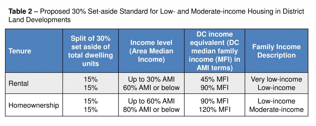
Table ES-1 shows that a transit approach matched with TDM and addressing chokepoints would rank highest in meeting the needs identified in the Purpose in Need, yet the study did not provide an integrated scenario linking transit, TDM and addressing chokepoints.

Since the Council of Governments adopted Region Forward Plan and Compact is framed as a transit-oriented future for the region, this study should have studied such a regional scenario. Once again a too narrow corridor focus improperly exclude the networked transit and TOD solution.

The Purpose and Need Statement fails to include what should be key goals for the corridor.  While the stated purpose ” is to improve multimodal mobility along the I-66 corridor by providing diverse travel choices in a cost-effective manner, and to enhance transportation safety and travel reliability for the public along the I-66 corridor,” it should also include goals to reduce demand for single occupant vehicle trips (including vehicle miles traveled and vehicle trips), by increasing mode share for non-auto trips through transit and changes in land use — changes in both the location of future development and improved community design which would result in higher transit ridership.  Again, looking to the long term, the stated goals cannot be met unless demand reduction goals are also a core goal and focus of this study.

In addition Purpose and Needs states, “the identified needs to be addressed include: transportation capacity deficiencies, major points of congestion, limited travel mode choices, safety deficiencies, and lack of transportation predictability,” orients the study too much toward capacity expansion and fails to include as key needs, such as reducing driving demand and improving land use to reduce driving demand and increase non-auto mode share.

The study is also artificially separated from the analysis of I-66 inside the Beltway even though a substantial proportion of inbound trips travels inside the Beltway and will have impacts all the way into D.C..

The study also inappropriately and without explanation excludes a dedicated transit and HOV scenario, leaving expanded HOV scenarios completely out of the study.

While the practice is to include all projects in the CLRP in the No Build scenario, inclusion of the controversial Route 234 extension (TriCounty Parkway western alignment) which would open up rural areas to more development and increase traffic would likely make the No Build perform worse than it would otherwise.

By separating a full tolling analysis from this story, it’s not possible to get a full picture of the effects of HOT lanes on transit usage, carpooling, general purpose lanes and parallel roadways. A full toll effects analysis should not be deferred to a separate study.  Moreover the relative benefits of privately tolled should be compared to public tolling, including the ability to use public tolling to fund more transit service in the corridor.

We were very concerned by the way Tiering of the I-81 study, which also failed to study a composite solution recommended by our group, was used to later foreclose the offering of a composite alternative at Tier 2. In addition, by tying the Tiering with the concept of “projects of independent utility,” a too general and flawed Tier 1 study can then open the door to allowing VDOT to move forward with whichever project it wishes and to foreclose more effective system wide alternatives.  Here, the issue may involve specific segments, but equally likely it would allow VDOT to move forward with just one component of the Integrated Concept Scenarios — such as tolled, managed lanes. In fact, the discussion of the ICS, very clearly proposes to allow VDOT to move forward with just one component. Read with other chapters of this study, it appears that the study is framed to favor the tolled, managed lanes.

The study cites the 1999 MIS in a history of previous studies but fails to note the stated preference of elected officials at that time (at least Fairfax County and probably others) for a transit-first solution.

We are also concerned that the Memorandum of Understanding, which we do not believe was subject to public comment, is also structured to focus on and favor a tolled, managed lane scenario, rather than another potentially non-tolled scenario.  The study states that per the MOA, decisions on the following will be made upon completion of the Tier 1 study:

  • The concepts to be advanced for the I-66 corridor, including transit improvements, transportation demand management strategies, and/or roadway improvements. Within these concepts, consideration will be given to managed lanes and tolling;
  • The general location for studying future highway and transit improvements in Tier 2 NEPA document(s);
  • Identification of projects with independent utility to be evaluated in Tier 2 NEPA document(s) and evaluated pursuant to other environmental laws; and
  • Advancing tolling for subsequent study in Tier 2 NEPA document(s).

With points one and four focused on tolling, and the potential intention to use the “projects of independent utility” to advance only the tolled portion of an ICS, the study appears to improperly lean toward one approach over others — the tolled, managed lanes.

The entry and exit tables are confusing because it’s not clear from the use of eastern, middle and western tables where the greatest demand may lie nor what the primary origin and destination data might be.

The COG growth projections which are used by this study fail to account for the dramatic changes in demographics, market demand and energy prices, nor a future of higher energy prices.  In turn, having had one of the largest expansions of the federal government in recent history shifting to a very likely downsizing, especially in defense, means that the growth projections should be reevaluated.  This can mean substantially less growth in outer areas. In turn, it’s important to note that the allocation of growth within the region is a subjective exercise and that high growth assigned to outer areas is not inevitable, nor is the form of that growth.

In addition, use of percentages for growth can be misleading and tables should be provided to show the magnitude of growth.  In addition, the report may overstate Gainesville/Haymarket growth while understating Tysons Corner growth.

While VDOT might argue that it is not responsible for land use, when billions of dollars are at stake, a thorough analysis of cost-effective alternatives must look at alternative growth scenarios.  And simply because an agency is not responsible for a subject area like land use, doesn’t mean it shouldn’t be studied in an EIS as a potential piece of an alternative. VDOT itself has published a report on the benefits of “Transportation Efficient Land Use” yet inappropriately eliminates such demand management solutions from this corridor.

Again in chapter 3 (figure 3-1), the process for evaluating solutions is flawed by ruling out TDM and system/out of corridor solutions early in the proces.

The four step evaluation approach (3-2) is also flawed for failing to look at alternative growth scenarios and changes in land use combined with other TDM approaches, meaning that the total travel demand entered in the first step may be higher than it would otherwise be.

We don’t understand and are concerned by the statement on 3-6 that “Demand is also based on
unconstrained capacity on I-66 itself (although connecting roads were constrained) in order to
ascertain total demand.”  That would seem to inflate the travel demand and overly favor capacity expansion solutions.

It doesn’t appear that the study factors in the congestion feedback signal from congestion in the general purpose lanes which would lead to higher transit use or new residents and jobs moving to transit-accessible locations as has been happening in recent years.

It’s not clear from Table 3-1 if the transit ridership numbers are based on transit-efficient land use or a continued pattern of auto dependent development in Prince William and western Fairfax, where transit efficient development might result in higher transit ridership.  It’s also not clear whether the managed lane scenario counts transit trips in the lanes — trips that could also be achieved by HOV/transit lanes without tolls.

Again, Table 3-3 shows that combining transit with a chokepoints solution could meet more components of the Purpose and Need than the managed lanes.

Table 3-4 lacks adequate supporting documentation and is a virtual “black-box” to the public.  The ICS alternatives fail to include non-tolled HOV with transit in any of the alternatives, which biases the study to managed toll lanes. It does not appear that the transit ridership factors in congestion feedback from the general purpose lanes.

It is unclear how Table 3-4 and Table ES-2 footprint widths are calculated.

The “Key Findings” (3-9) don’t appear to be fully substantiated.  For example, it states:

  • “Other than the two-lane Managed Lanes concept (ML2) which accommodates autos and buses alike, single mode improvement concepts result in large corridor width, high cost, poor efficiency, and/or inability to serve total demand.”  Would that indeed be true of Metrorail or an HOV/BRT approach, with each tied to transit-efficient land use?
  • Another stated finding is that:  “The share of trips made either by transit or in multi-occupant vehicles for those ICSs that perform best against the Table 3-4 metrics reach over 80 percent. While accommodating such high percentages of trips by transit and multi-occupant vehicles would be very difficult, the fact that these percentages are so high is indicative of the benefit of including transit and managed lanes that can carry large numbers of person-trips as part of the solution.”  If that is the case, why not use an HOV and transit solution rather than only use tolled, managed lanes with the various transit modes?
  • Another stated finding is that “The projected peak period travel demands in the corridor highlight the need for a transportation solution that provides space efficiency – the ability to carry large numbers of persons within limited spaces. Managed Lanes and fixed-guideway transit (in descending order of carrying capacity: Metrorail Extension, Bus Rapid Transit, and Light Rail Transit) provide space efficiency.  But do managed lanes really provide space efficiency when the interchange needs of having dual sets of ramps are factored in?  The interchanges on the 495 HOT lanes have taken a substantial number of acres with a profound impact on surrounding communities.

Conclusion:  It is critical to get this Tier I study right because completion of this study will likely foreclose consideration of alternatives at the Tier 2 stage. The study appears biased toward the managed lane approach by failing to analyze non-toll HOV with transit alternatives and by failing to analyze a composite transit, transit-efficient land use, TDM and chokepoint alternative (a systems oriented approach and one that would meet the regional goals in Region Forward).  The study does not substantiate the footprint, ridership, table 3-4 ratios, and costs; and the “findings” are also unsubstantiated. Effects on land use are not addressed.

  • We request the opportunity for additional time for peer review of this study by independent transportation planners.
  • We also request that VDOT’s report on Transportation Efficient Development be considered in this study along with the goals of Region Forward.
  • Finally we request that this study be delayed until the composite alternative that we highlight is analyzed using alternative growth and land use.

Thank you.

Stewart Schwartz
Executive Director

Testimony before the D.C. Historic Preservation Review Board, Support for McMillan Sand Filtration Plant Master Plan Update

Please accept our testimony on behalf of the Coalition for Smarter Growth. My organization works to ensure that transportation and development decisions in the Washington D.C. region accommodate growth while revitalizing communities, providing more housing and travel choices, and conserving our natural and historic areas.

We wish to express our support for the revised Master Plan for the McMillan Sand Filtration Plant proposal. The new plan takes an already thoughtful plan and provides additional open space and careful treatment of the unique historic resources of the site. The plan will restore and provide public access to key elements of the distinctive historic resources. This would not be possible without the redevelopment program that helps pay for the cost of the restoration.

We recognize that the expansion of park space on the site was in part driven by D.C. Water’s enhancement of stormwater management and flood mitigation efforts. The expanded park space, driven both by D.C. Water and public demand for a larger park, has traded off a significant loss of affordable housing for the space. This is a major disappointment and a loss of D.C.’s use of public lands to address the housing needs of many residents, especially at lower income levels of 60 percent of AMI and below.

Notwithstanding this significant loss, we recognize the important historic preservation, public space, housing, and commercial space contributions of the revised Master Plan. For decades, access to this large area was prohibited, creating a wide gap between surrounding activities and neighborhoods. The revised plan would make this historic resource featured in a major public park a citywide destination.  The Master Plan honors and replicates the historic landscape elements of the Olmsted Walk that have disappeared from the site. We agree with the staff comment that additional work should be done with DDOT to ensure that the Olmsted Walk connection to the sidewalk design is more than a standard sidewalk.  This might require some flexibility in DDOT’s design standards.

The plan appropriately focuses taller office buildings towards Michigan Avenue and tapers building heights and forms as the development moves south to meet rowhouse neighbors. The plan adds separation to the neighborhood to the south with a large public park. Large scale buildings are needed close to Michigan Avenue to give a sense of enclosure and connect to the Washington Hospital Center. Eventually, we hope these new buildings will encourage reconfiguration of the hospital complex to create more pedestrian-oriented designs.

Preservation of Cell 14 and recreation of the Olmstead Walk along North Capitol Street highlight the historic features of the site; however, they should be balanced with the need to support a better pedestrian environment along these busy streets by better connecting the pedestrian to adjacent uses on the site.

The plan for complementary new uses of retail, offices, and residential will strengthen the facing hospital complex and reconnect the site the city. These proposed uses are likely to build upon and amplify the contribution that current hospital center-related activities make to D.C.’s economy and employment base.  While the northern components of the plan better connect the site to its surroundings, the large park and recreated Olmsted Walk also allow the site to stand out as a distinctive and special place.

Overall, we support the revised master plan as a sensitive approach to preserving and making publically accessible this industrial architectural and public works heritage. The housing, retail, and office components help address the needs of a growing city and hospital district. Given that we have already lost a significant number of low income housing units planned in the first Master Plan, we ask that historic design guidance work with existing proposed levels of housing and commercial space, and not force further reductions.  While we would like to see significantly more affordable housing in this plan, the redevelopment plan does contribute to important community and citywide needs. The proposed plan for preservation and development is a compromise to enable the restoration of this distinctive historic resource.

Thank you for your consideration.

Cheryl Cort
Policy Director

Testimony to Ms. Lynn Robeson, Esq., Zoning Hearing Examiner Re: 4831 West Lane LLC, Local Map Amendment G-954 and Development Plan Amendment DPA 13-01

Please accept these comments on behalf of the Coalition for Smarter Growth. Our organization works to ensure that transportation and development decisions in the Washington, D.C. region, including the Maryland suburbs, accommodate growth while revitalizing communities, providing more housing and travel choices, and conserving our natural and historic areas.

We want to express our strong support for the West Lane multi-family residential project because it enhances the diversity of housing choices and number of MPDUs within such close proximity to the Bethesda Metro station. This is a great benefit to the county and the region because the building provides more housing, especially affordable housing, in a job-rich area, next to Metro. This reduces overall traffic in the region, shortens commutes, reduces household transportation costs, and gives more moderate income households access to the jobs and amenities of a highly desirable community.

After reviewing the proposed plans and public record, consulting with residents, and walking the site, we believe that the project offers its housing benefits through a sensitive and appropriate approach to the building design. The proposed building provides an attractive contribution to a pedestrian-oriented environment and complements the existing nearby residential buildings.

We are especially pleased to see the building’s relationship to Montgomery Lane which forms a supportive urban pedestrian environment. The existing and planned buildings along the north side of Montgomery Lane form a continuous street edge, which the proposed West Lane building completes. The 12 foot upper story setback provides visual interest to the building and addresses concerns of neighbors. A greater setback is not necessary or desirable. A greater setback will not further enhance the ground-level pedestrian environment. In addition, further unnecessary shrinkage of the building could threaten the number of MPDUs provided, while offering no increased public benefit.

The public use space provided at the corner of West Lane and Montgomery Lane is a good approach if it incorporates the main entrance of the building. The public use space at this location achieves two important objectives. It decreases the mass of the building by stepping back the building’s frontage, but still maintains the important building line along the street edge. It also provides a usable urban public space for people to wait or meet friends. The success of the public use space is dependent upon the entrance of the building opening up onto the public use space.

The appropriately scaled building and the well planned public use space are compatible with the neighborhood. The increased number of units ensures more pedestrians on the street – which is consistent with the Sector Plan and a benefit to all. The Sector Plan’s housing diversity goals are also furthered by the West Lane project. The proposed units are smaller and more affordable than those offered in surrounding buildings and include a substantial number of MPDUs – all within 950 feet of the Metro station.

For all of these reasons, the Coalition for Smarter Growth urges approval of the 4831 West Lane project.

Thank you for your consideration.

Sincerely,

Cheryl Cort
Policy Director

Helping Virginia grow — wisely

The March 13 editorial “Leave well enough alone,” on the Virginia transportation bill, characterized the coalition that defeated the 2002 referendum on a sales tax for transportation as “anti-growth activists and anti-tax conservatives.” This is a false characterization.

The leading activists have consistently supported planning for robust growth in the region. During the referendum debate, the Coalition for Smarter Growth and the Piedmont Environmental Council released a plan for redevelopment and economic growth that focused on the areas around the region’s rail stations. The region has embraced this vision through its Region Forward plan and local implementation of new transit-oriented development projects.

In Fairfax County, business and political leaders recognize transit-oriented development as the pivot for continued economic growth. The Coalition for Smarter Growth has endorsed and supported millions of square feet of development and thousands of housing units that bolster a smart-growth future. The Post should recognize this.

Douglas Stewart, Fairfax

The writer is a grants specialist at the Piedmont Environmental Council.

Read the original article here >>

Testimony before Ms. Françoise Carrier, Chair of the Montgomery County Planning Board re: Long Branch Sector Plan Comments

Dear Chair Carrier and members of the Board:

Please accept these comments on behalf of the Coalition for Smarter Growth. Our organization is a regional organization focused on ensuring transportation and development decisions are made with genuine community involvement and accommodate growth while revitalizing communities, providing more housing and travel choices, and conserving our natural and historic areas.

We appreciate this planning effort to prepare for the Purple Line stations and ensure that land use and the street network can support a more walkable, transit-oriented community. While we support the plan overall, we have specific concerns related to preservation of the affordable housing in the area, and the retention of small, local businesses.

Affordable Housing

The plan provides a useful analysis of anticipated trends in housing, showing increasing rents of low priced rental housing with or without the Purple Line, but the loss of a substantial number of market affordable units in the redevelopment scenario envisioned by the plan. Under either scenario, greater commitment by Montgomery County government is needed to preserve and expand housing opportunities for low and very low income households in the area. Without this commitment, we will either lose the affordability of low rent market affordable units slowly through rising rents, or more rapidly with the arrival of the Purple Line. We urge the Planning Board to work with the county to create an affordable housing strategy in conjunction with the sector plan. This effort should coordinate with the Department of Housing and Community Affairs to identify resources and properties that could be acquired and redeveloped with additional subsidy to secure and expand affordable housing in the area.

The sector plan relies almost exclusively on MPDUs as the response to the need for maintaining affordable housing in the area, while acknowledging much more needs to be done. We commend the 15% MPDU requirement, however, this standard falls short in a number of ways. The 15% standard for the plan can help address concern that the CR zones are reducing production of MPDUs to the minimum required. The 15 percent requirement, however, needs to be matched with assurance that the 22 percent bonus density is achievable. Where the CR zone standards are a constraint in achieving the 22 percent bonus density, this constraint should be removed. The height limit is often the key constraint to achieving the 22 percent bonus, thus this limit should be modified to allow for the full realization of the MPDU bonus.

Given the challenges with finding resources to preserve and build affordable housing in this area, we urge the Planning Board to leverage its use of MPDUs to create more below-market rate units. We suggest further incentive by creating a new 20% MPDU set aside standard that offers additional FAR and height.

Complete Streets

We appreciate the plan’s goal to create a safe, walkable environment and the intention to designate the area as a Bicycle and Pedestrian Priority Area. We ask that as streets are redesigned, particular attention is given to improving the safety of pedestrian movements at major intersections. State and county street design standards should be reconsidered in light of the goal that public rights of way are places are truly inviting for pedestrians and shared spaces for all users.

Small business retention and assistance

We appreciate the plan seeking to retain small businesses and encourage public private partnerships to support affordable space for businesses providing unique products and services. The specifics of how this will be accomplished, however, need to be better addressed. The ability of the CR zone to support this goal should be carefully assessed. Assistance from county programs should also be better connected to the changes the plan seeks through rezoning.

Overall, all we appreciate the efforts of this plan to anticipate and guide change. We remain concerned however, that this plan and a coordinated response with the county is falling significantly short of addressing the housing needs of low income families in the area. We ask that the Planning Board reconsider the tools it can leverage, as well as better coordinate a response with the county which can provide resources and programs to address housing and small business needs.

Thank you for your consideration.

Sincerely,

Cheryl Cort
Policy Director

Testimony before the Hon. Muriel Bowser, Chair, Committee on Economic Development and Housing Council of the District of Columbia regarding: DMPED Performance Oversight – affordable housing in public land deals

Please accept these comments on behalf of the Coalition for Smarter Growth. We are a regional organization based in the District of Columbia focused on ensuring transportation and development decisions are made with genuine community involvement and accommodate growth while revitalizing communities, providing more housing and travel choices, and conserving our natural and historic areas.

Recommit to leveraging public land dispositions for very low income housing in mixed use projects

Table 1We know that while the city has grown in population and income, low income D.C. residents are experiencing even greater difficulties finding housing they can afford. Thus public lands, and every other realistic tool we have available, should be used to help address this pressing need. Our recent report, Public Land for Public Good, shows that the District has and can do great things with its city-owned land. The creation of mixed income housing opportunities on public land is an important source of affordable housing for our residents.

We highlight the Hine Jr. High School redevelopment project next to the Eastern Market Metro station as a leading example of what a public land disposition should do. The project will offer a great mix of uses, close to 30 percent affordable housing, and a design compatible with a historic district. All of this occurs next to a Metro station, close to the core of the city. The project has been in process since 2008 when the former school site was offered for redevelopment. The project will provide 163,000 square feet of office space, 40,000 s.f. of retail, and a total of 159 housing units. Of the total, 46 units will be affordable, or 29 percent. The mix of affordability for the housing units is a good example of what the city should be seeking in LDAs: 5 units will be affordable at 30 percent AMI, 29 units at 60 percent AMI, 12 units at 80 percent AMI (in lieu of IZ). Other public benefits include reconstruction and opening of a block of C Street SE, and a public plaza along C Street.

The Hine School project pre-dates the current administration. We are concerned that the commitment to affordable housing in recent solicitations for public land dispositions, especially at the lowest income level, is declining. I would be surprised if a DMPED Land Disposition Agreement (LDA) ever again results in 30 percent AMI housing. Current practice by DMPED asks that any residential component meet or exceed Inclusionary Zoning standards of 8-10 percent set aside at 50-80% AMI. IZ is the law and what is required for any residential development. We should expect much more for public land.

Table 1 shows the affordable housing set side and income targeting that was the practice of the last decade for solicitations in public land dispositions. Currently, DMPED’s solicitations provide little of the specificity that was the practice in the past. We urge the council to ensure that we are making the most of the unique opportunity to leverage the value of the District’s land to create more affordable housing through the land disposition process. We ask that the council recommit the District to clearly requesting and prioritizing proposals that offer substantial amounts of affordable housing, including units affordable to those earning 30 percent AMI. As was the practice in the past, we ask that requests specify the city is seeking 20 percent to 30 percent of the total number of residential units affordable at 30 percent and 60 percent AMI for rentals, and up to 80 percent AMI for ownership. We suggest table 2 as a model. In addition, we ask that DMPED better coordinate with other agencies to pool resources to ensure the production of housing affordable at deeply affordable levels as a part of larger mixed income or all-affordable development.

Table2

Management of Affordable Dwelling Units

Since 2009, DHCD created a group to manage affordable dwelling units (ADUs) created through LDAs and Zoning Commission actions, along with IZ units. Given the many challenges to helping moderate and low income households buy and maintain affordable homes, we suggest that this process might be best done through DHCD contracting with a qualified nonprofit. Resale assistance for a price controlled home could benefit from extra attention that a nonprofit could provide to a seller. While we have suggested this for IZ units, we also think that ADU management would similarly benefit.

Thank you for your consideration.

Sincerely,

Cheryl Cort
Policy Director